Undeclared North Korea: Hoejung-ni Missile Operating Base
Key Findings
- Located 338-kilometers north of the demilitarized zone and only 25-kilometers from the Chinese border in Chagang Province, the Hoejung-ni missile operating base will, according to informed sources, likely house a regiment-sized unit equipped with intercontinental ballistic missiles (ICBM).
- Should operational ICBMs not become available in the near term, it is likely that intermediate range ballistic missiles (IRBMs) will be deployed. A Hwasong-12 IRBM was launched from Chagang Province on January 30, 2022.
- North Korea is not known to have ever made specific references to the existence of the Hoejung-ni missile operating base. This is the first in-depth open-source reporting confirming the ICBM base, though previous reports of an older base at Yongjo-ni surmised of its existence.1
- Although construction began almost 20 years ago, the Hoejung-ni missile operating base represents one of the latest Strategic Forces bases to be completed.
- This long construction timeline suggests a considerable level of prior development planning that is rarely appreciated and was likely linked to projected ICBM developments and basing needs.
- The base is one of approximately 20 ballistic missile operating bases that have never been declared by North Korea. Additionally, it does not appear to have been the subject of any denuclearization negotiations previously conducted between the United States and North Korea.
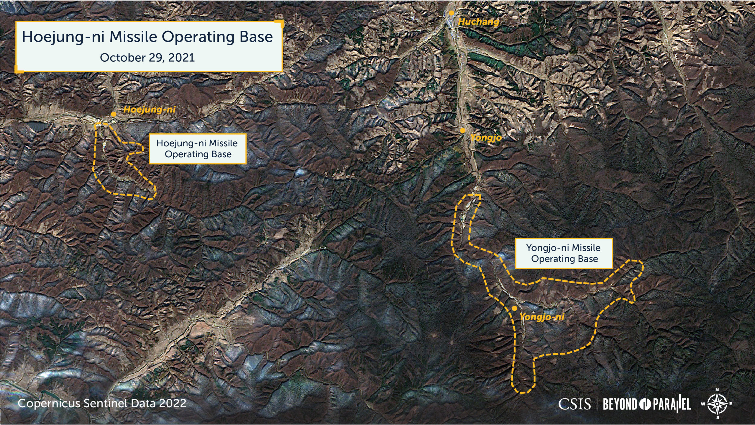
The Hoejung-ni (회중리) missile operating base is located in Hwapyong-gun (화평군, Hwapyong County), Chagang-do (자강도, Chagang Province), 280-kilometers northeast of Pyongyang, 338-kilometers north of the demilitarized zone, 420-kilometers northeast of Seoul and 1,285-kilometers northwest of Tokyo. Notably, the base is also located 25-kilometers from the border with China and 15-kilometers northwest of the older Yongjo-ni (영저리) missile operating base.2
The overall layout and design of the Hoejung-ni base are different than from those of older missile operating bases and more closely aligned with those of the Sangnam-ni missile operating base. The timing of the construction of these two bases suggests that their construction may have been sequenced, Sangnam-ni being first, as part of a third phase in North Korea’s development of its strategic or rear ballistic missile belt.3 This missile belt is itself a component of an extensive and growing nation-wide dispersed ballistic missile network subordinate to the Strategic Force—the Korean People’s Army (KPA) organization responsible for all long-range ballistic missile units.
Although construction began almost 20 years ago, the Hoejung-ni missile operating base represents one of the latest Strategic Forces bases to be completed. The fact that construction of it began so long ago suggests not only significant resource constraints, but also a considerable level of development planning that is rarely appreciated by outside experts and was likely linked to projected ICBM developments and basing needs.
According to informed sources, the KPA unit that will eventually be based at Hoejung-ni will be equipped with intercontinental ballistic missiles (ICBM). Should operational ICBMs not become available in the near term, it is likely that the unit will be equipped with intermediate range ballistic missiles (IRBMs) – a Hwasong-12 IRBM was launched from Chagang Province on January 30, 2022. When this occurs, the unit will represent a vital component of what is presumed to be North Korea’s evolving ballistic missile strategy, expanding existing strategic-level deterrence and strike capabilities. Until more is known, however, the latter capability should be characterized as a “potential” or “emergency” launch capability as the true operational status of North Korea’s various ICBM programs and the units equipped with them remain among the critical unknowns concerning the Strategic Force.
North Korea is not known to have ever made specific references to the existence of the Hoejung-ni missile operating base and its national designator is unknown.4 The provisional title of Hoejung-ni missile operating base is derived from its location adjacent to the small town of Hoejung-ni, sometimes identified as Hoejung-dong.
While construction has proceeded at a somewhat slower pace than other missile operating bases, it has been steady and logically sequenced. Satellite imagery as of January 21, 2022, indicates that—similar to the Sangnam-ni missile operating base—the Hoejung-ni base will likely house a regiment-sized missile unit. The base is active and well-maintained by North Korean standards, and minor development of the base’s infrastructure is continuing.
Base Organization
Hoejung-ni missile operating base (41.369883, 126.913631) encompasses approximately 6 square kilometers and extends approximately 4 kilometers up a small, isolated wooded mountain valley running in a generally north-to-southeast direction. The valley itself is on the south side of the Taehoedong-chon (대회동천, Taehoedong stream). This valley is bisected by a meandering stream, has several small branch valleys, and is flanked on the east, west, and south by three mountains—the Chongsok-san (청석산, Chongsok Mountain), Hoeyang-san (회양산, Hoeyang Mountain) and Hyeondo-san (현도산, Hoeyang Mountain). Most of the area encompassed by the base consists of unoccupied tree-covered mountains and a few small agricultural and forestry activities that support the base. Located immediately outside of the base are the village of Hoejung-ni and the Hoejung-ni railroad station, both of which undoubtedly provide some level of support to the base.
As of January 21, 2022, the base can be functionally divided into six general activities: entrance and security; headquarters and administration; hardened drive-through missile checkout facilities (sometimes referred to as missile support facilities); primary underground facility; secondary underground facility; and a variety of small housing, support, and agricultural support activities.
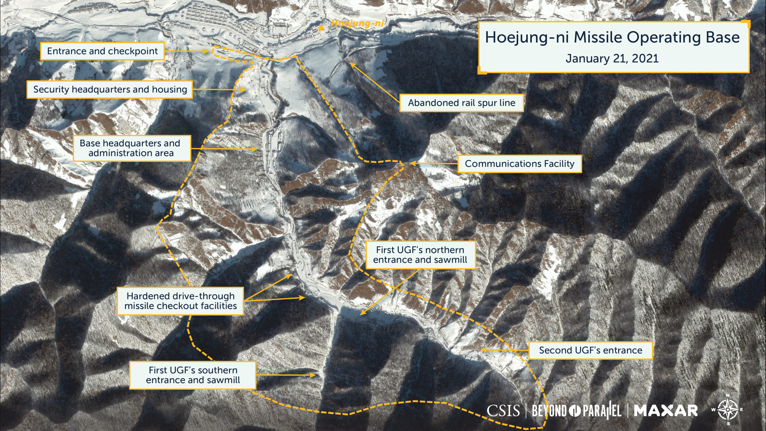
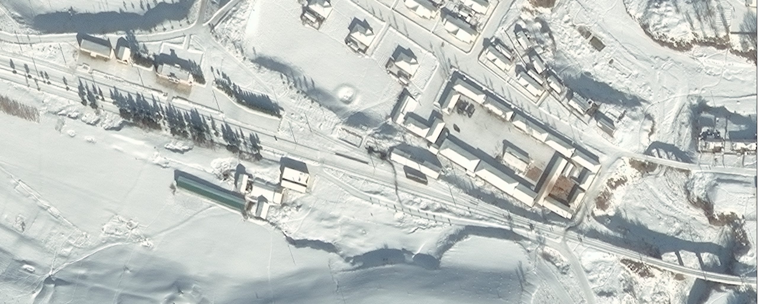
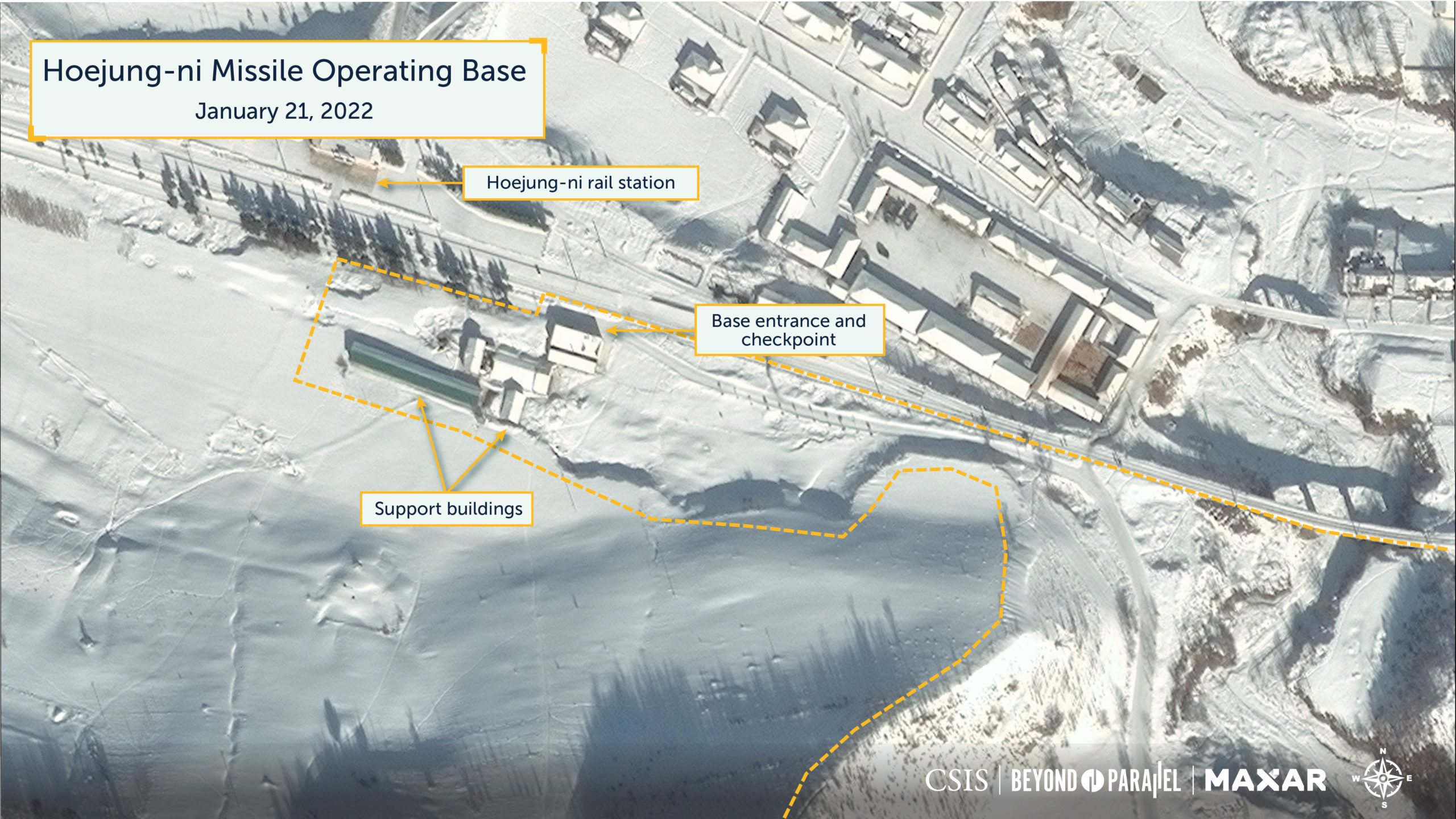
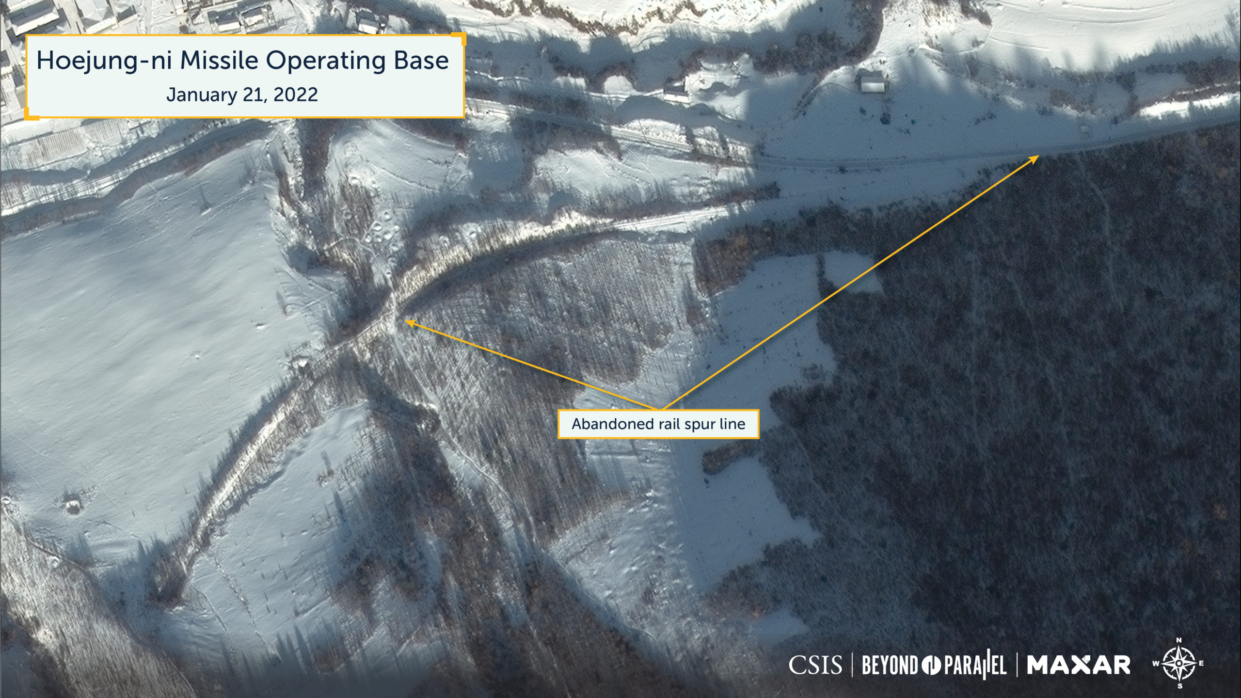
Located adjacent to the Hoejung-ni railroad station at the base of the valley is the base’s entrance and checkpoint (41.384978, 126.906453). It consists of two large structures, one small structure, and a greenhouse. It has remained unchanged since late-2019. An inactive (likely abandoned) rail spur line branches off the main Hyesan-Manpo-Chongnyon rail line approximately 1.3 kilometers east (41.385879 126.922805) of the base’s entrance and checkpoint. The spur runs approximately 725-meters in a curving southwest direction before terminating (41.383043 126.915528) just outside the presumed perimeter of the Hoejung-ni missile operating base. This spur line is unlikely to have contributed to its development and, unless extended, will not contribute to future operations.
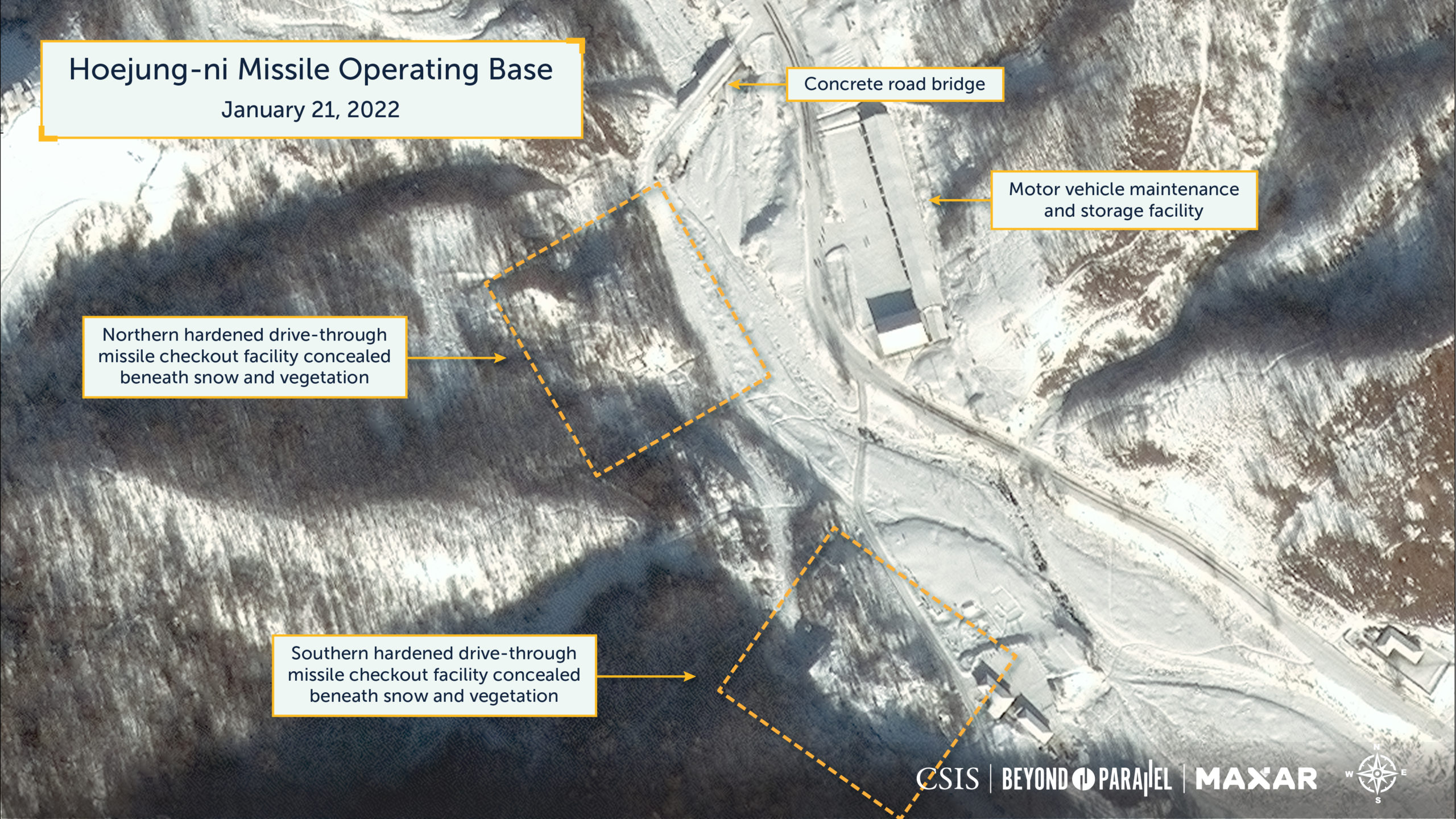
What is believed to be the base security headquarters compound is located approximately 400-meters up the valley road (41.382416, 126.909427). It consists of seven administration and housing buildings, a greenhouse, small motor vehicle maintenance facility, storage facility, two circular gardens, and a formal base entrance sign erected over the road at the south end of the area (such signs are often seen at important KPA bases). Since December 2019, the area has witnessed only minor changes.

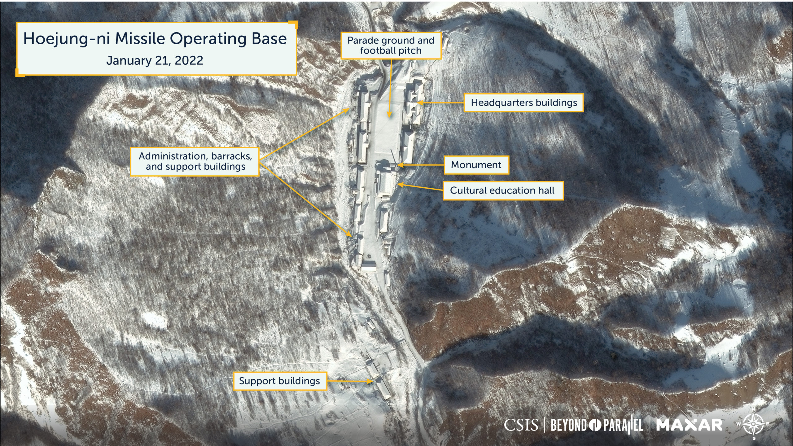
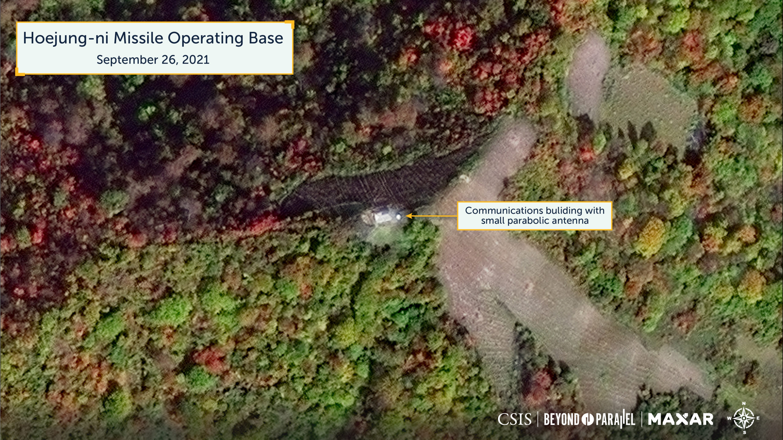
The base’s headquarters and administration compound is located approximately 900-meters up the valley (41.378688, 126.910740) and consists of approximately 20 large and medium-sized buildings (including a small greenhouse and large cultural education hall with monument) and a parade ground/football pitch. Its size and layout are similar to those seen at other missile operating bases. Immediately south of the area is a small agricultural support compound with four buildings. In addition, sometime between 2015 and 2017, a small communications facility (41.377742 126.923232) was established on a lower peak of the Hoeyang-san, 1.1 kilometers east of the headquarters and administration compound—to which it is connected by buried cable. Since 2017, these activities have witnessed only minor changes.
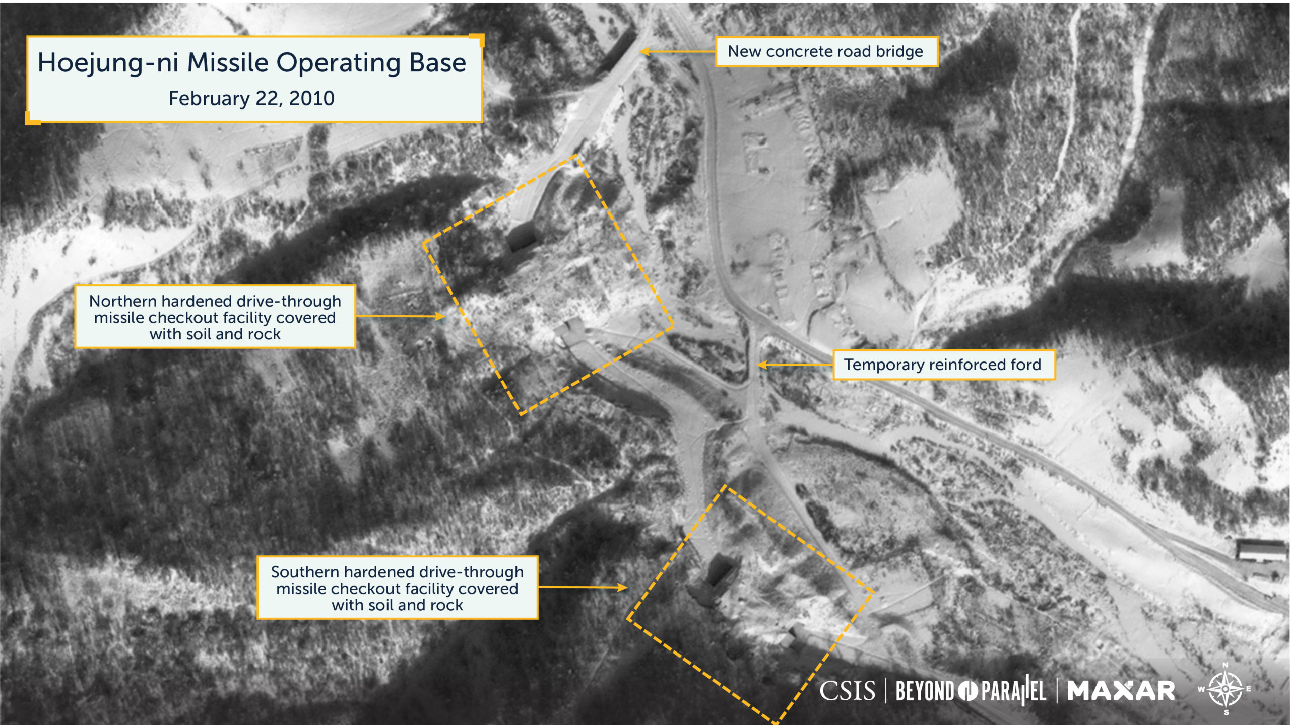
Located approximately 2-kilometers up the valley, on the west side of the stream, are the base’s two hardened drive-through missile checkout facilities (41.370204 126.912578 and 41.368924 126.913694). These are used for missile arming, fueling, systems checkout, and maintenance operations. Each facility consists of a large concrete-reinforced shelter cut into the side of the adjacent mountain; the shelter measures approximately 35-meters-long, has a 25-meter opening at each end, and is covered with soil and rocks with vegetation planted on top. The length and size of the openings are of sufficient size to accommodate all known, and likely planned, KPA ballistic missile transporter-erector-launchers (TEL), mobile-erector-launchers (MEL), transporter-erectors (TE), and missile support vehicles and equipment. It should be noted that reported KPA wartime ballistic missile doctrine calls for these launchers to exit the base to conduct launch operations.5 The maturing vegetation consisting of trees and bushes on top of each structure makes it increasingly challenging to locate them using commercial satellite imagery in all but winter months, during which long shadows also provide a challenge.
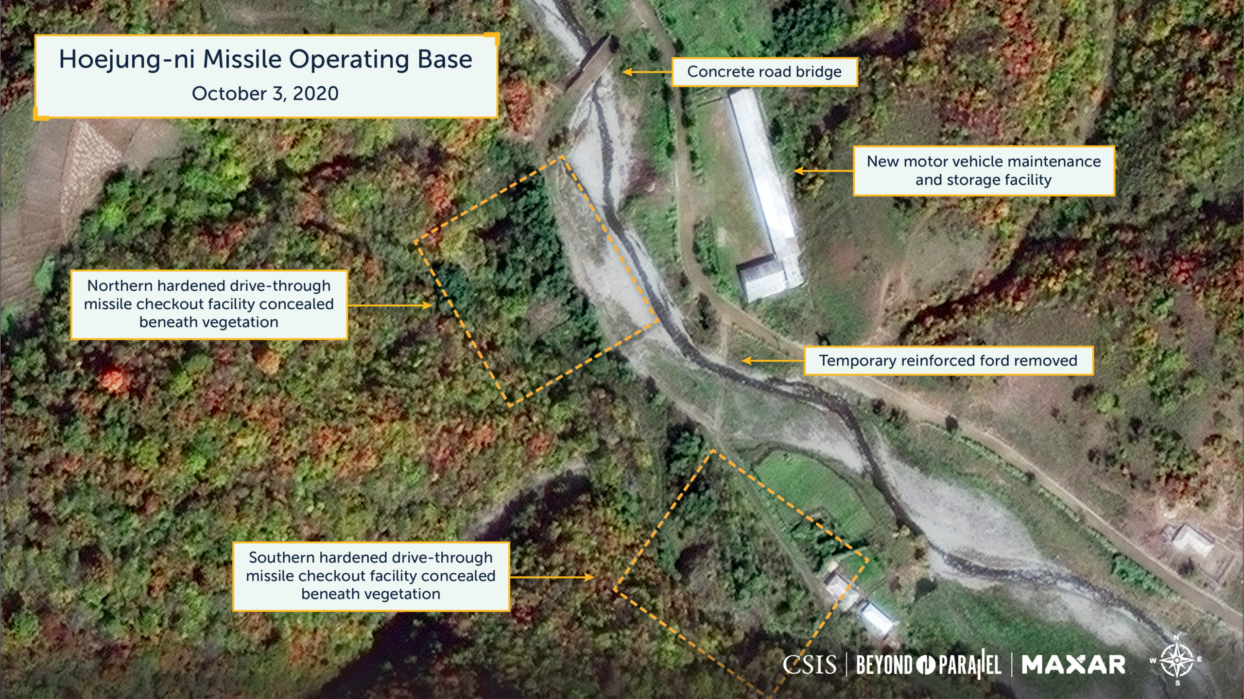
Located on the east side of the stream across from the drive-through facilities is a large motor vehicle maintenance and support facility (41.370537 126.913751) for the unit’s support vehicles.
To support movement across the stream and through these facilities, two reinforced concrete deck bridges were constructed during 2008-2010. The first bridge, approximately 21-meters-long-by-7.5-meters-wide, is located approximately 200-meters northeast (41.370998 126.913043) of the exit to the northern drive-through facility. The second bridge, approximately 11-meters-long-by-7.5-meters-wide, is located approximately 730-meters southeast (41.367516 126.922529) of the southern entrance to the drive-through facility.

The imagery acquired during the construction of the two hardened drive-through missile checkout facilities provides a unique opportunity to gain insight into the KPA’s construction sequence and timing for these distinctive facilities.
Construction Sequence for the Hardened Drive-Through Missile Checkout Facilities
| June 2005 | Excavation operations have begun for the northern facility |
| December 2005 | Concrete walls had been poured at the northern facility Excavation operations have begun for the southern facility |
| November 2006 | Roofs have begun to be poured at northern facility Walls poured for southern facility |
| April 2008 | Roof on northern facility approximately 75% complete Roof on southern facility approximately 40% complete |
| February 2010 | External construction and back filling of northern facility complete External construction of southern facility complete and backfilling ongoing |
| December 2015 | Construction and both facilities complete and the planting of trees and bushes on both facilities for camouflage and concealment was ongoing |
| October 2017 | Vegetation on top of both facilities mature enough to provide moderate camouflage and concealment |
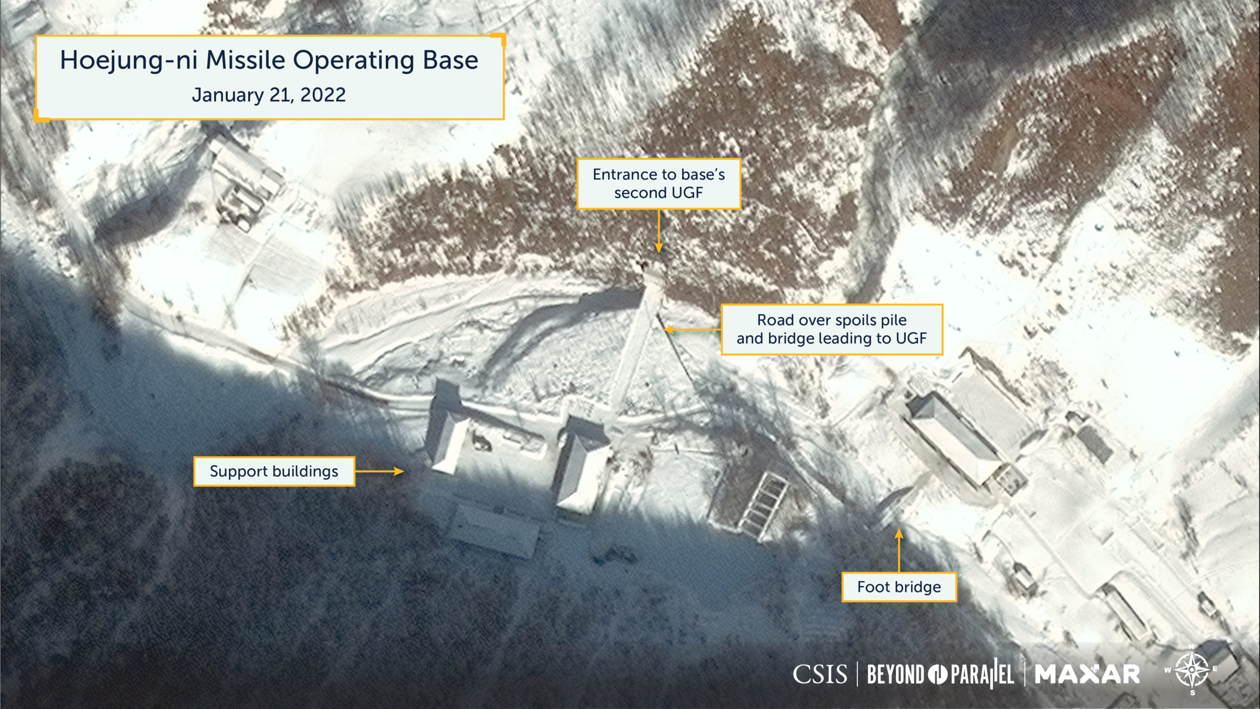
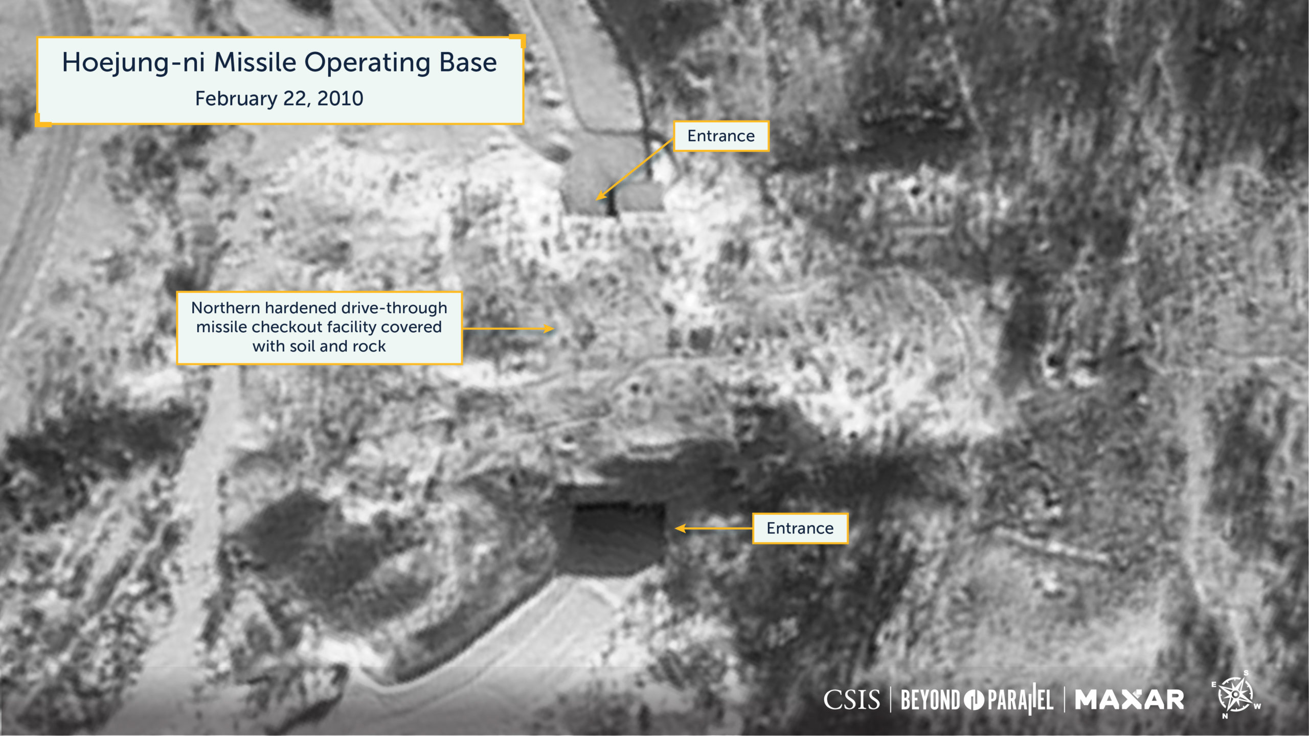
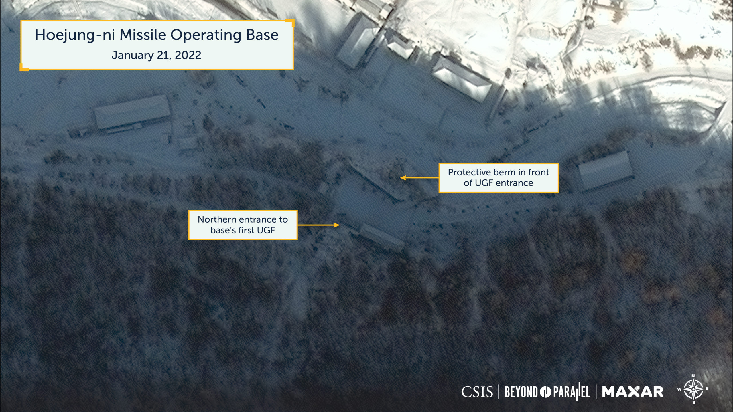
Approximately 2.5-kilometers up the valley, built under a mountain west of the stream, is the base’s primary underground facility (UGF) with two entrances—northern (41.366821 126.919889) and southern (41.365287 126.915955). The direct line distance between the two entrances is approximately 375-meters. However, given what is known concerning large North Korean UGF construction, it is likely about 450-meters-long and potentially longer. The openings for both entrances are approximately 6.25-meters-wide and, like the drive-through facilities, can accommodate all known and likely planned launchers and missile support vehicles and equipment. Located approximately 30-meters in front of the northern entrance is a soil and rock protective berm measuring approximately 38-meters-long and supported by a concrete wall facing the entrance.
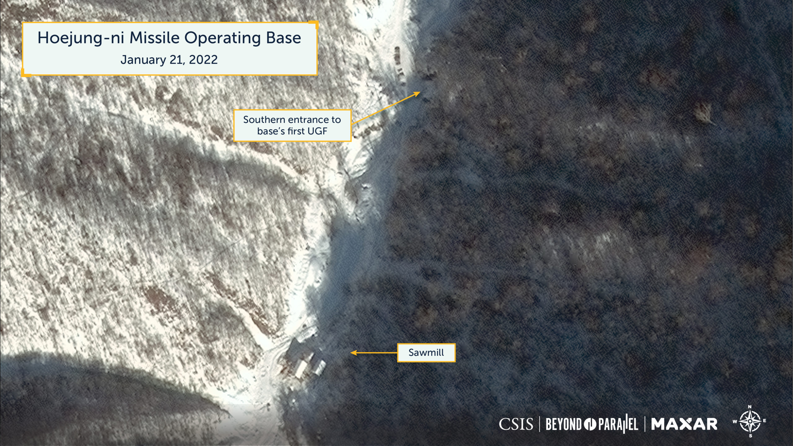
Located southwest of the northern UGF entrance and approximately 400-meters southwest of the northern UGF entrance, up a branch valley extending to the south, is the southern UGF entrance consisting of the entrance portal and a small soil and rock bridge with a culvert. Approximately 150-meters further south of this entrance is a small sawmill (41.364011 126.915273) with a small bridge over the stream. This sawmill has been visible in all imagery, and piles of woodchips are occasionally observed during the summer months.
What appears to be a second UGF (41.365161 126.928513) is located approximately 3.4-kilometers up the valley on the east side of the stream. Excavation of this facility began sometime during 2016-2017 once a bridge across the stream was built. To facilitate this activity, two small support areas were established adjacent to the entrance and on both sides of the stream. The growth of the spoil piles indicates that excavation continued until about 2020, and an image from January 21, 2022, shows no significant activity on the spoil piles or at the portal since that time. This suggests that excavation is either complete or has been suspended.
There are several unorthodox aspects to the location and construction of this facility that have led some informed sources to argue both for and against its use as a UGF, with some suggesting that it is a small mining facility.
- While other North Korean ballistic missile operating bases often have UGF entrances near small fordable streams, none have UGF entrances directly on a stream or require a bridge immediately outside the portal to access them. Having either of these characteristics increases the facility’s vulnerability to neutralization from even minor artillery, missile, or air strikes.
- Almost all North Korean ballistic missile operating bases have large protective berms in front of their UGF entrances to help protect them from attack. To date, this facility has none, and it is unlikely that an effective one could be built on the west side of the stream.
- While most existing bases have wide radius turns, the road leading from this facility has a tight 90° turn radius that could present a challenge for ICBM launchers to navigate, especially for longer towed transporter-erectors.
- No North Korean missile operating bases have active mining operations within their confines.
A final determination as to the intended function of these facilities remains elusive.
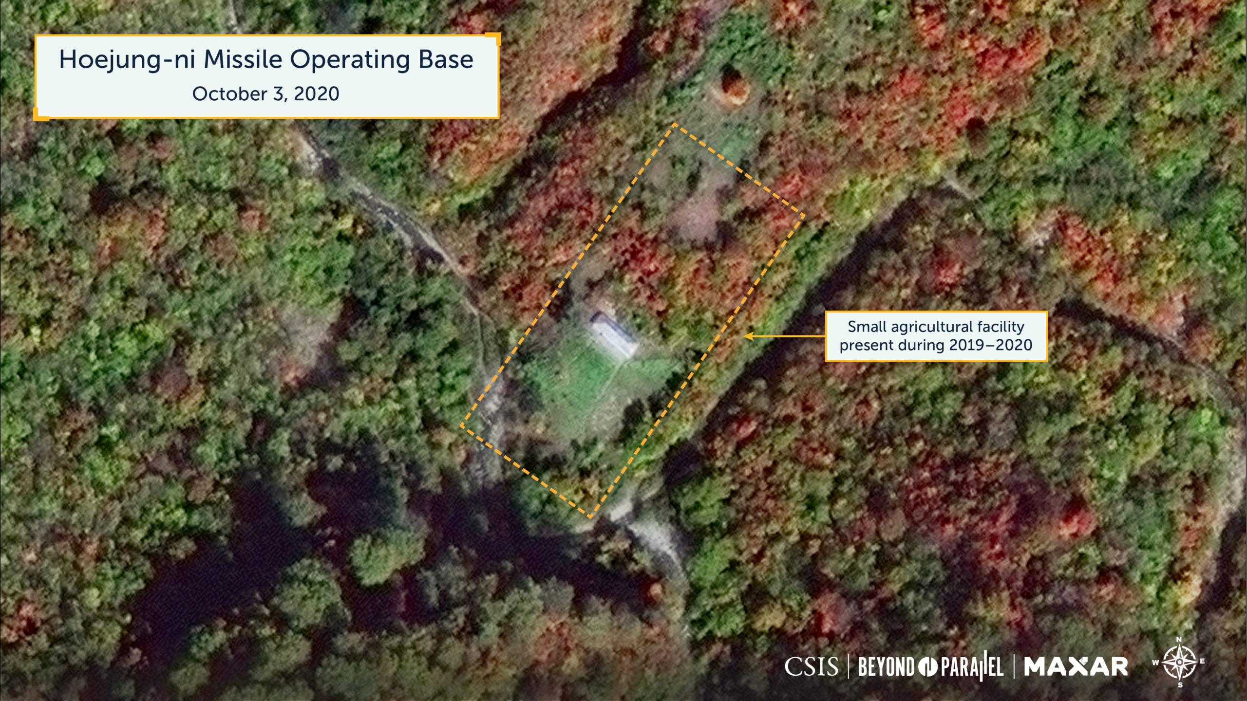
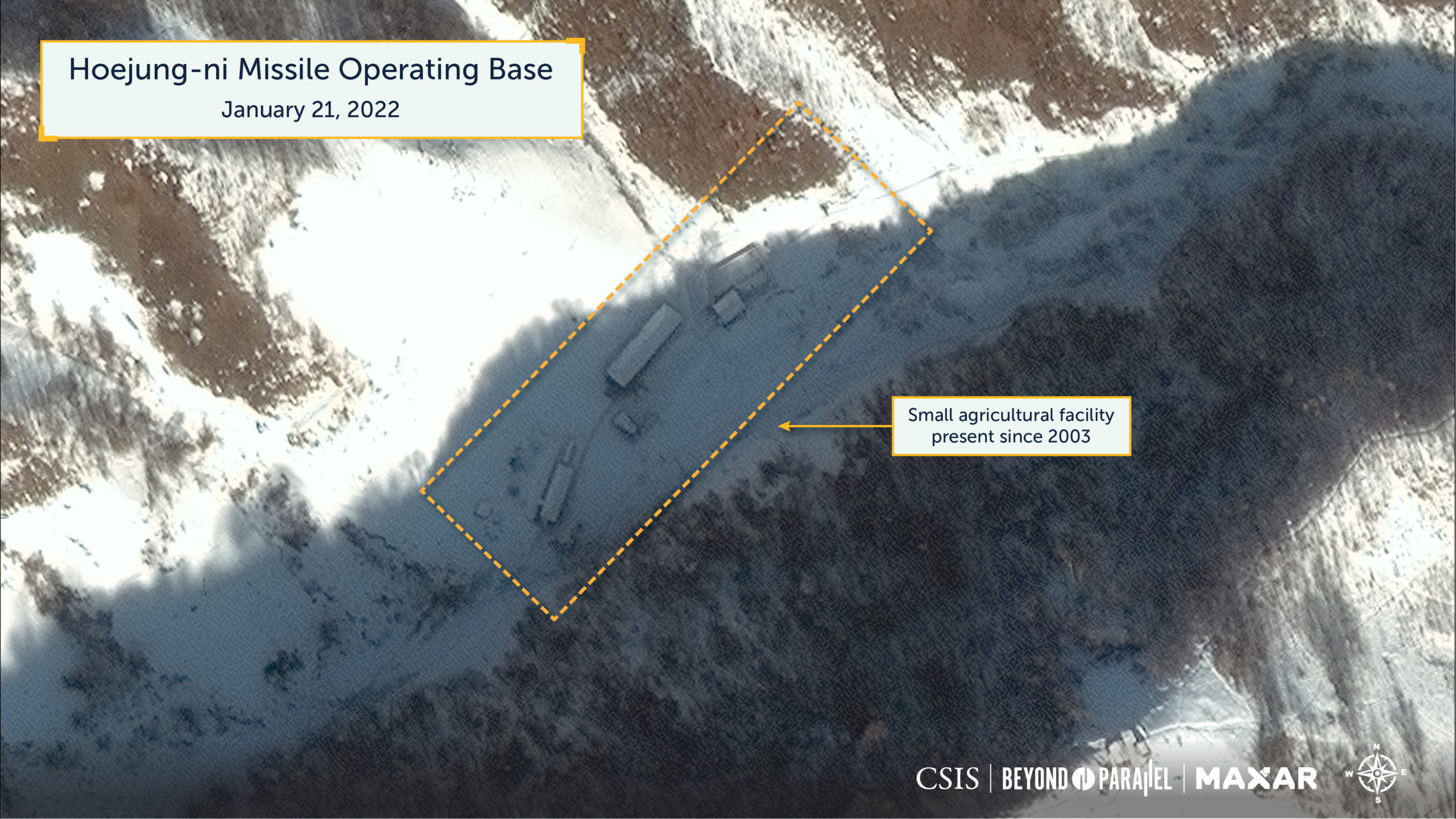
In addition to the above activities, since at least the early-1970s and until the present, small agricultural and forestry activities (many often transitory) have been observed in satellite imagery dispersed along the length of the valley and on the adjacent slopes where the Hoejung-ni missile operating base would be built.6 Today, those agricultural and forestry activities within or adjacent to the current base’s presumed perimeter are likely used to support the base.7

As of January 21, 2022, the base is active and being well-maintained by North Korean standards. As best as can be determined from satellite imagery, informed sources, and what little data is available, the base is ready to receive an operational ICBM unit.
Order-of-Battle
The organizational relationship between the Hoejung-ni and Yongjo-ni missile operating bases is unclear. However, it would not be unusual for both bases being in the same geographic area to be subordinate to the same intermediate headquarters beneath the Strategic Force headquarters.
As noted above, informed sources indicate that a KPA ballistic missile unit equipped with ICBMs will be based at Hoejung-ni sometime in the future. As of January 2022, there are no indications that this unit is present. The reasons for this are likely some combination of the following:
- While much of the base appears to be externally complete, minor construction is ongoing and the final installation of equipment (and potentially minor construction) of the primary UGF may be ongoing.
- There are challenges manufacturing finished ICBMs which are operational qualified, as opposed to those for test and evaluation. This is likely a result of both supply chain constraints and competition for limited resources among various programs and design bureaus.
- There are issues revolving around the supply of sufficient numbers of fully trained missile operators and support personnel and limited opportunities to train with operational missile systems. However, this latter factor may be easing, given the recent missile launches during late-2021 and early-2022.
Similar to the Sangnam-ni missile operating base, the layout, organization, and size of the infrastructure visible in satellite imagery of Hoejung-ni suggest that the base will eventually house a regiment-sized unit consisting of a headquarters, small service elements, and several firing batteries. With this said, it should be noted that the organizational structures of KPA ballistic missile units may not neatly fit into western organizational structures.
Due to the strategic importance of the KPA’s ballistic missile operating bases and concerns of either pre-emptive or wartime airstrikes against these facilities, most missile operating bases have some level of organic air defense capabilities, are within the coverage of the national air defense missile shield, or both. This does not appear to be the case with the Hoejung-ni missile operating base. There are no readily identified fixed anti-aircraft artillery positions within 10-kilometers of the base and the nearest readily identifiable surface-to-air missile base (an SA-2/S-75 Dvina unit) is at Kanggye 50-kilometers to the southwest. However, it is likely that when a ballistic missile unit is finally stationed at the base, it will possess an organic air defense unit equipped with both light AAA and shoulder fired air defense missiles (e.g., SA-7, SA-14, SA-16, etc.). The nearest Korean People’s Air Force (KPAF) airbase is the Manpo-up Airfield 53-kilometers to the southwest. As it is dirt-surfaced and houses an An-2 transport unit, it provides no support to the Hoejung-ni missile operating base.
Development
2003-2006
The author first became aware of what is now identified as the Hoejung-ni missile operating base during a conversation with an informed source in the early 2000s—shortly after the first signs of construction were observed.8 From that time until 2018, no public information of significance concerning the facility was available. In 2018, Dave Schmerler and Jeffery Lewis published a blog posting on the Yongjo-ni base that also described the Hoejung-ni facility.9
The location selected for the Hoejung-ni base is within a small, isolated wooded mountain valley adjacent to the Hoejung-ni railroad station on the south side of the Taehoedong-chon (대회동천, Taehoedong stream). This valley is bisected by a stream and flanked on three sides by mountains. Prior to the commencement of base construction, only minor agricultural activity around a tiny agricultural hamlet of about 34 structures, and minor logging operations scattered further up the valley were present.
As best as can be determined from satellite imagery, construction of the Hoejung-ni missile operating base began sometime prior to 2003—perhaps as early as the late-1990s. The earliest readily available clear high-resolution satellite image of the area, collected on May 6, 2003, shows that the base entrance and checkpoint consisted of main and support buildings on the south side of the Hoejung-ni railroad station and along the road leading up the valley. Further up the valley, two support and construction worker housing areas support the construction of a nearby underground facility. It is believed that many of the construction personnel stationed here at this time were specialized engineering troops from the KPA’s Military Construction Bureau.10 As noted above, the timing of this construction may be related to the construction progress at the Sangnam-ni missile operating base, which had progressed to a point that permitted the release of a portion of the specialized engineering troops from the KPA’s Military Construction Bureau to begin work excavating the Hoejung-ni base’s UGF.
The 2003 image shows that the first support and construction worker housing area was located approximately 2.5-kilometers up the valley road on both sides of the stream at the intersection of the main valley and a branch valley. It consisted of approximately 55 structures of various sizes and types (livestock pens, greenhouses, housing, etc.). Among these were four square compounds for worker housing and equipment storage. Most notable, however, was evidence of the earliest stages of excavation for two entrances to an underground facility.11 At the northern entrance adjacent to the support area, excavation, grading, and construction of the concrete portal for the UGF are visible. The southern entrance was located 400-meters to the southwest of the northern entrance, up a branch valley extending to the south. Located here were the portal on the east side of a small stream, four structures of various sizes on both sides of the stream, and a soil and gravel access road with culvert across the stream. Approximately 150-meters further up this branch valley was a small sawmill with a small bridge over the stream. At both UGF construction sites, excavated spoil was being spread out locally.
Located approximately 3.1-kilometers up the main valley road was the second support and construction worker housing area that consisted of five compounds of various sizes with a total of approximately 35 structures (e.g., worker housing, equipment storage, agricultural support, and a sawmill). These were distributed on both sides of the stream and connected by one road bridge and two small footbridges.
Imagery collected on June 13 and December 10, 2005, show that construction of two hardened drive-through missile checkout facilities had commenced and that construction operations at the two UGF entrances were expanding by this time.
Located approximately 2-kilometers up the main valley on the west side of the stream, excavation for the first of two hardened drive-through missile checkout facilities had begun during early 2005. By December 10, 2005, construction on the first facility had reached the stage where concrete walls had been poured, and excavation for the second had recently begun. The excavated soil and rock were placed adjacent to the construction sites to be used for future backfill and overhead cover of the two facilities. To support this construction activity, a construction worker housing and support area was built on the east side of the valley, and a small ford across the river was reinforced with soil and rock excavated from the facilities. The housing and support area consisted of approximately 25 structures of various sizes and shapes (including a motor vehicle maintenance and storage facility).
In the December 10, 2005, image, a concrete portal had been built at the northern UGF entrance, fresh spoil pile activity was observed being deposited 40-meters from it, and six small structures had been built. At the southern UGF entrance, a concrete portal was under construction, a small walled compound on the west side of the stream had been built, the number of small structures on both sides of the stream had increased to 17, and a soil and rock bridge had been built across the stream. The beginning of a spoil pile was observed approximately 120-meters north of the portal on the east side of the stream.
Elsewhere in the base, the 2005 imagery shows only minor activity typical of what would be expected, such as the addition of a wall around the support building at the main entrance, razing or construction of small agricultural-related structures, etc.
2006-2009
Three satellite images collected during November and December 2006 show that progress was slowly continuing at the two hardened drive-through missile checkout facilities. Most noticeable was that the first-stage excavation for the second facility had been completed, and several concrete walls had been poured. A November 15, 2006, image shows that construction work on the UGFs was continuing, as evidenced by expanding spoil piles and activity at both portals. At the northern portal, activity was observed on the hillside above it, and a concrete wall had been erected approximately 35-meters in front of it. The latter would serve as the face of a protective berm being built from the rock and gravel being excavated from inside the facility. At the southern portal, a finished concrete portal was now visible, and a small footbridge had been built. The same November 15 image shows the first signs of activity at the second support and worker housing area for what would become a second UGF. A small temporary bridge was erected across the stream to the east bank.
Two years later, an image collected on April 15, 2008, shows continued progress on the two hardened drive-through missile checkout facilities, with much of the concrete roofing on the first facility having been poured, and progress being made on pouring the walls and portions of the concrete roof on the second facility. To support future operations of the drive-through facilities, construction of a concrete road bridge approximately 200-meters northeast of the northernmost drive-through facility had recently begun, while a second concrete road bridge located approximately 730-meters southeast of the southern drive-through facility was partially complete. Rock and gravel excavated from both drive-through facilities were used to build up the shoulders of the bridges and banks along the stream.
The two years between 2008 and 2010 witnessed significant development of the Hoejung-ni missile operating base, as indicated by a satellite image collected on February 22, 2010.
As far back as 2003, the area 400-meters up the valley road from the entrance was simply cultivated fields. By February 2010, however, a small new housing and support area consisting of ten new buildings had been erected. The location, layout, and type of buildings suggest that this area was being developed into a compound for the base’s security headquarters and housing.
Approximately 375-meters further up the valley road, all but five of the 34 structures had been razed and a new support building erected at the small unnamed agricultural hamlet. This area would subsequently be developed into the missile base’s headquarters and administration area with barracks, support buildings, and a cultural education hall.
2010-2016
The satellite image acquired on February 22, 2010, shows that both hardened drive-through missile checkout facilities had been externally completed, back filling of the northern facility had been completed, construction of southern facility had been completed, and backfilling operations were ongoing. Both were approximately 35-meters-long and had 12-meter-wide openings at both ends. Internal work, however, would likely continue for some time afterward. In addition, construction of the reinforced concrete deck bridges supporting the hardened drive-through missile checkout facilities was completed sometime during 2008-2010. This, in turn, allowed for the nearby reinforced ford to be removed and restored to its original status.
This same February image shows that major excavation and construction activity on the primary UGF had apparently been completed, although interior work undoubtedly continued for some time. All but nine of the structures composing the support and construction worker housing area adjacent and across the stream from the northern UGF entrance had been razed. Additionally, all the spoil from the excavation had been graded out to form a raised area and bank for the stream and the protective berm in front of the entrance measuring approximately 38-meters-long had been completed. About all that externally remained to finish was the planting of trees and bushes on the slope above the entrance. Likewise, at the southern UGF entrance, all but one structure had been razed, and the spoil graded out north along the stream. The sawmill further up the branch valley, however, remained.
Further up the valley, at the location where a second UGF would be soon built, a satellite image acquired on February 22, 2010, shows that most of the original worker housing and agricultural support buildings had been razed, leaving three buildings and seven smaller structures. The small temporary bridge across the stream had been removed.
With much of the heavy construction work on the hardened drive-through facilities and UGF completed by 2010, the need for large numbers of workers decreased, and construction activity at the base shifted to less demanding operational infrastructure development.
A satellite image collected on December 19, 2015, shows that at the base entrance and checkpoint, both original buildings had been razed and replaced with a new building and large greenhouse. The only notable change at the base security compound was the construction of two large circular gardens. Such gardens are often observed at major military and industrial facilities near headquarters or administrative areas. Further up the valley, the headquarters and administration area had undergone significant development since 2010. By 2015, four large headquarters or administration and four smaller housing or support type buildings had been built, and a cultural education hall was under construction.
The same December 2015 image shows that both hardened drive-through missile checkout facilities were now covered with additional soil, and trees and bushes had been planted. A small building had been built at the southeast corner of the northern facility, and a somewhat larger building constructed 30-meters east of the southeast corner of the southern facility. Two new buildings were constructed across the stream from the northern facility, including a sizeable motor vehicle maintenance and storage facility in the previously razed worker housing and support area.
In the area around the northern entrance to the primary UGF, significant changes had occurred. At the razed support and construction worker housing area, 22 new structures were built, including a barracks compound, agricultural support compound with a large greenhouse, and a large building adjacent to the UGF entrance. In addition, the vegetation on the hillside above the entrance had taken root and appears to have been added to. No significant changes were observed at the southern UGF entrance and the nearby sawmill.
Further up the valley where a second UGF would soon be built, the December 19, 2015, image shows that significant changes had taken place. Six new support buildings had been built in the previously razed worker housing and agricultural support area. Immediately to the south and across the stream, there were some minor changes to the few remaining support buildings, including the addition of a new greenhouse. Significantly, construction had begun on a permanent concrete bridge at the same location as the earlier temporary bridge. Interestingly, no discernable activity was noted on the east side of that earlier bridge from 2006 until 2014. This suggests that this earlier bridge was likely used to support engineering investigation for the forthcoming excavation and bridging.
2017-2022
Two years later, an October 8, 2017, image shows no changes at the base entrance and checkpoint. However, numerous changes had taken place at the base security headquarters compound. One building was razed and replaced by a larger L-shaped building, two additional buildings (including a second L-shaped building) had been built, landscaping in and around the previously noted circular gardens had been completed, and a greenhouse and small pond had been built. Five satellite images from 2018 and 2020 show that the buildings used as housing or offices had been razed and then replaced by four large ones and that both a formal entrance sign over the road had been erected and a small motor vehicle storage facility had been built at the south end of this area. An image acquired on October 16, 2019, shows that two buildings had been added to the entrance and security compound. Since then, satellite imagery shows that only very minor changes have occurred in the entrance, checkpoint, and security compound.
At the base headquarters and administration area, the October 2017 satellite image shows that construction of the cultural education hall had been completed, and two monuments were erected. Most of the small temporary buildings previously seen here had been replaced by larger permanent buildings—some of which were barracks. Several additional support buildings had been erected—including two at the small support area immediately to the south. This brought the number of structures in the area to approximately 20. Since then, satellite imagery shows that the area has witnessed only minor changes such as the construction or razing of small structures.
Sometime between 2015 and 2017, a small communications facility was established on a lower peak of the Hoeyang-san 1.1 kilometers east of the headquarters and administration area. This facility consists of a repurposed forestry building with a small parabolic antenna. It is connected to the headquarters and administration area via buried cable. The facility hasn’t witnessed any significant changes since that time.
While some internal work at the hardened drive-through missile checkout facilities likely continued for some time, by October 8, 2017, both were completed and covered with additional soil, with trees and bushes planted. Since then, only minor changes have been observed. The growth of trees and vegetation on top of the facilities has made it increasingly challenging to locate them using commercial satellite imagery in all but winter months.
At the entrances to the primary UGF, no changes of significance have been observed in satellite imagery from 2017 to the present. However, as with the hardened drive-through facilities, the growth of trees and vegetation on the slopes above the entrances has made it increasingly challenging to locate them using commercial satellite imagery. The same is somewhat true for the protective berm in front of the northern entrance.
At the second UGF, the image from October 8, 2017, shows that a 9-meter-by-6.5-meter concrete bridge had been completed, and excavation on the east side of the stream had begun. Two bridge abutments were poured on the west side of the bridge and most of the spoil from the excavation activity are seen being spread out in a fan shape between these abutments. A second smaller spoil pile was also observed approximately 25-meters south of the bridge on the east side of the stream.
The following year, a September 22, 2018, image shows that both the main and secondary spoil piles had doubled in size and that several small structures had been built in the support area on the west side of the stream and a large building built in the support area across the steam to the east. By March 10, 2019, these small structures had been razed, a gravel road had been laid across the main spoil pile to the bridge, a concrete portal to the UGF had been built, and the spoil piles continued to grow slowly. The most recent image from January 21, 2022, shows that there have been no significant changes to the spoil piles or at the portal, and only minor changes such as the addition of a new footbridge have taken place elsewhere in the area.
Research Notes
This report, as are the others in this series, is based upon an ongoing study of the Korean People’s Army ballistic missile infrastructure begun by Joseph S. Bermudez Jr. in 1985. This study is, in turn, based upon numerous interviews with North Korean defectors, declassified documents, open-source reporting, and interviews with -government, defense, and intelligence officials around the world. Accuracy in any discussion of North Korea’s nuclear, biological, chemical, or ballistic missile programs is always a challenge, and while some of the information used in the preparation of this study may eventually prove to be incomplete or incorrect, it is hoped that it provides a new and unique look into the subject. The information presented here supersedes or updates previous works by Joseph S. Bermudez Jr. on these subjects.
Although 31 high- and medium-resolution satellite images were analyzed during the preparation of this report, the images ultimately presented in this report were purposely selected for their sensor resolutions, off-nadir angle, unique view, or absence of foliage. The latter allows for a more unobstructed and detailed view of the structures and activities within and around the Hoejung-ni missile operating base.
Gazetteer of Named Places
| Name | Coordinates |
| Chongsok-san (청석산) | 41.370556 126.875278 (West) |
| Chung-dong (중동) | 41.388333 126.893889 |
| Hoejung-ni (회중리) | 41.386486 126.914728 |
| Hoejung-ni missile operating base | 41.369883 126.913631 |
| Hoeyang-san (회양산) | 41.370556 126.944167 (East) |
| Hyeondo-san (현도산) | 41.341944 126.928611 (South) |
| Kanggye-si (강계시) | 40.961944, 126.547778 |
| Yongjo-ni (영저리) | 41.329722, 127.083889 |
The authors wish to thank Seiyeon Ji, Andy Lim, Morgan Waterman, Seongjoon Hwang, Sang Jun Lee, and Dana Kim for their invaluable research in support of this project.
References
- Schmerler, Dave and Jeffery Lewis. “North Korean Missile Base At Yeongjeo-Dong,” Arms Control Wonk, December 6, 2018, https://www.armscontrolwonk.com/archive/1206442/north-korean-missile-base-at-yeongjeo-dong/. This blog posting was subsequently the source for Choe Sang-hun. “North Korea Is Expanding Missile Base with Eye Toward U.S., Experts Warn,” New York Times, December 6, 2018. https://www.nytimes.com/2018/12/06/world/asia/north-korea-missile-bases.html. ↩
- Yongjo-ni is sometimes referred to as Yongjo-ri, Yongjo-dong, or Yeongjeo-dong. ↩
- Bermudez Jr., Joseph S., Victor Cha and Lisa Collins. “Undeclared North Korea: Missile Operating Bases Revealed,” Beyond Parallel, November 12, 2018, https://beyondparallel.csis.org/north-koreas-undeclared-missile-operating-bases/. ↩
- All KPA units have official and cover designations. The latter is what is commonly seen being used in North Korea media. For example, a fictional unit mentioned in Rodong Sinmun might have a cover designation of “KPA Unit 702,” however, its official designation is the “123rd Infantry Division.” Some units also have an honorific name assigned to its official designation in recognition of some significant accomplishment. Using our example “KPA Unit 702” would be the “123rd Guards Infantry Division.” The “Guards” honorific having been applied in recognition of the unit’s accomplishments during the Korean War. To make this more complicated it is not unusual for a cover designation to be randomly changed. Cover designations are sometimes referred to as “military unit cover designation” (MUCD). ↩
- Interview data acquired by Joseph S. Bermudez Jr.; Yi Yong-chong: “Taepo Dong-2 Manufactured at Namp’o on Its Way in Camouflage to Launch Site,” JoongAng Ilbo, June 20, 2006; and Hwang, Yang-joon. “North Korea Builds Six Bases for 550 km-range Missiles,” Hankook Ilbo, October 27, 1999. ↩
- Additionally, at various times over the years, there have been several small footbridges across the stream up and down the valley. ↩
- Most Korean People’s Army units are responsible for producing a portion of their own food each year. ↩
- The national designator for the Hoejung-ni missile operating base is unknown. ↩
- Op cit. Schmerler, Dave and Jeffery Lewis. ↩
- Interview data acquired by Joseph S. Bermudez Jr. A brief description of the specialized engineering troops of the KPA’s Military Construction Bureau can be found in Bermudez Jr., Joseph S. Shield of the Great Leader: The Armed Forces of North Korea, (London: I.B. Taurus), 2001. ↩
- Interview data acquired by Joseph S. Bermudez Jr. ↩