Yongbyon Declassified Part I: Early Work on First Nuclear Research Reactor
Despite being the subject of intense study for almost 60 years there is remarkably little independently verifiable information concerning the development of North Korea’s nuclear infrastructure available at the unclassified level. This is especially true for the formative days of the program from the 1960s through the 1980s. Beyond Parallel, through a series of reports entitled “Yongbyon Declassified,” intends to take a small step towards rectifying this situation by taking advantage of high-resolution (better than 5-meter resolution) satellite imagery acquired by early U.S. reconnaissance programs. The historical imagery from these programs has been declassified during the past 25 years by components of the Central Intelligence Agency (CIA) and National Geospatial Intelligence Agency (NGA).1
Key Takeaways
-
- There is a common misperception that North Korea began development of its nuclear weapons program in the late 1980s. Analysis of declassified satellite imagery from U.S. reconnaissance programs, however, shows that sometime between June 1963 and July 1964 North Korea had already started construction on the nuclear research facilities at Yongbyon. The construction site was located 85 kilometers north of Pyongyang.
- The development of the nuclear facility can be traced to technical and scientific cooperation initiated between the Soviet Union and North Korea in the late 1950s and early 1960s.
- North Korea received its first reactor, a modified 4-megawatt thermal (MWt) IRT-2000 research reactor, in mid-1964 from the Soviet Union. Prior to that time excavation work to lay the foundation for the reactor and related operational and administrative facilities had already begun.
- In 1964, the Yongbyon nuclear research facilities initially occupied an area of approximately 0.9km2 but by the 1980s the research center had expanded to an area of 3.5 km2.
“Yongbyon Declassified” specifically analyzes declassified KEYHOLE (KH) KH-4A (2.7-meter resolution) and KH-4B (1.8-meter resolution), KH-7 (1.8-meter resolution) and KH-9 (0.6- to 1.2-meter resolution) imagery from the CORONA, GAMBIT and HEXAGON reconnaissance programs respectively. While some of this imagery is nominally available through the U.S. Geological Survey (USGS), much had yet to become available in the public archive and had to be specifically scanned for this project. Additional imagery, not available through the USGS, is available at the National Archives at College Park, Maryland.2
This report series will look at the development of North Korea’s Yongbyon Nuclear Research Center on an approximately yearly basis from 1964 through 1984.3 Subsequent to this Beyond Parallel will review the development of other components (e.g., uranium mining, uranium milling, etc.) of North Korea’s nuclear infrastructure.
Yongbyon
The roots of North Korea’s nuclear program are generally traced back to its participation in the March 1956 founding of the Soviet Union’s Joint Institute for Nuclear Research at Dubna, Moscow Oblast.4 This institute was established to train scientists from member states in theoretical and applied nuclear science and to share nuclear related research. Three years later, during September 1959, North Korea and the Soviet Union concluded a nuclear cooperation agreement that included provisions to provide financial, technical and scientific assistance to construct a nuclear research center in North Korea.
The site chosen for this new nuclear research center was located approximately 85 km north of the capital Pyongyang and 4.75 km west-southwest of the ancient walled city of Yongbyon, P’yŏngbuk. It was from this city that the facility took its public facing name—the Yongbyon Nuclear Research Center.5
Topographic maps from the 1950s and declassified satellite imagery from 1964 show that the specific location chosen for the Yongbyon Nuclear Research Center was an isolated agricultural area along an inside bend of the Kuryong-gang (i.e., the Kuryong River).
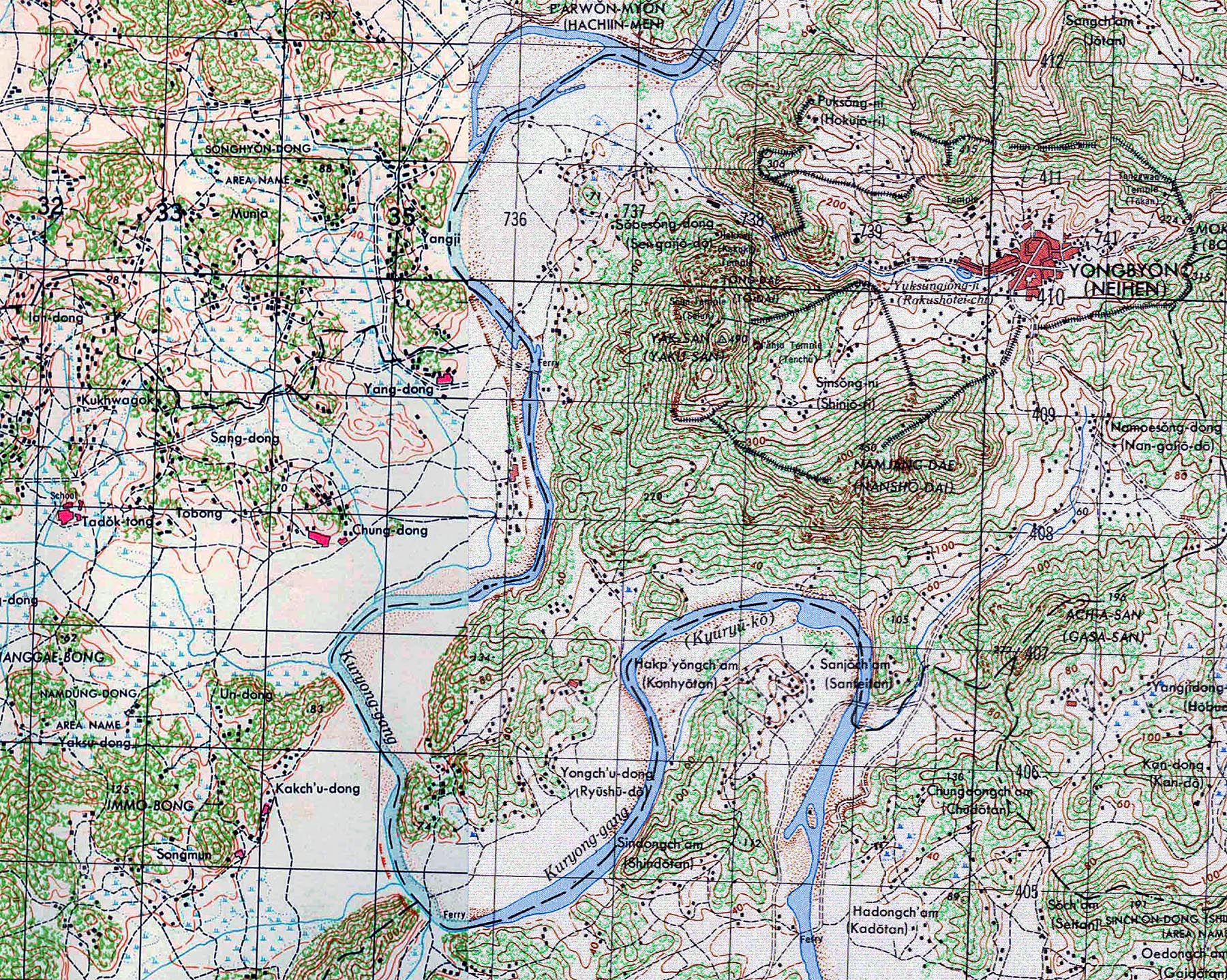
Image: U.S. Army topographic map of the Yongbyon area from 1950.
While the North would go on to establish a number of small nuclear-related research institutes at various educational and scientific facilities around the country the Yongbyon Nuclear Research Center has remained the center of the nation’s nuclear program.
KH-4A Mission 1008 (July 15, 1964)
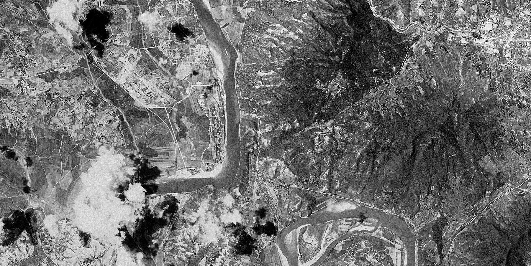
One of the earliest declassified satellite images of the Yongbyon area was taken on July 15, 1964 during KH-4A Mission 1008.
![]()
Image: An overview of the Yongbyon area showing the location of the first stages of construction on the Yongbyon Nuclear Research Center, the city of Yongbyon and Yak-san mountain—where Kim Il-sung eventually built a small villa (CIA, KH-4A).
Initially, the new facility would encompass an area of only 0.9 km2 that was generally known as Pun’gang-ni (Pun’gangni-nodongjagu) and included the small agricultural villages of Sang-dong and Yang-dong as well as several tiny unnamed hamlets.6
![]()
Image: An overview of what will become the northern section of the Yongbyon Nuclear Research Center showing the site for the IRT-2000 research reactor construction in relation to the villages of Yang-dong, Sang-dong, Pun’gang-ni and Chung-dong (CIA, KH-4A).
During mid-1964, the Soviet Union provided the North with its first reactor, a modified 4-megawatt-thermal (MWt) IRT-2000 research reactor, a critical assembly and associated fuel assemblies that would be installed in the operations area at the Yongbyon Nuclear Research Center. The reactor, critical assembly and fuel were initially provided without IAEA safeguards. However, as the result of a 1977 agreement they were placed under safeguards.
Sang-dong
Excavation operations for the establishment of operations, administration and support area along the river and the conversion of Sang-dong and Yang-dong into housing, government and cultural areas appear to have begun during early-1964.
![]()
Image: A close-up view of the village of Sang-dong showing that it has been partially razed and excavation for the construction of new housing and support facilities has begun. The existing railroad station and railroad tracks are just visible (CIA, KH-4A).
Yang-dong
![]()
Image: A close-up view of the site of the IRT-2000 research reactor and support buildings under construction southeast of the village of Yang-dong. The ground to the southwest is being cleared for construction of administration and laboratory buildings in what will eventually become a larger support area (CIA, KH-4A).
Despite a few scattered clouds, the 2.7-meter resolution image shows the Yongbyon area primarily engaged in typical rural agricultural activity while the early stages of construction work on the new Yongbyon Nuclear Research Center are clearly visible. The excavation work for the IRT-2000 research reactor and associated operations and support buildings is underway, and the villages of Sang-dong and Yang-dong have been partially razed and excavation has begun for housing and cultural facilities.
Pun’gang-ni
The site of the future 5MWe and ELWR reactors is occupied by a small agricultural hamlet (believed to be Pun’gang-ni) and fields.
![]()
Image: A close-up view of the agricultural activity in the Pun’gang-ni area south of the IRT-2000 research reactor construction site. This area will eventually be developed into a larger support area and the location for the 5MWe and Experimental Light Water reactors. The rail bridge over the Kuryong-gang is visible at the bottom of the image (CIA, KH-4A).
Yongch’u-ri
Only agricultural activity is observed on the south side of the Kuryong-gang in the Yongch’u-ri (i.e., Yongch’u-dong) area where the future fuel fabrication facility, Radio Chemistry Laboratory, gas centrifuge facility, isotope production facility and other facilities will be built. Much of the other industrial (e.g., sand and gravel plants, precast concrete plant, etc.) and civilian infrastructure (e.g., communications facility, etc.) in the area has yet to be built.
![]()
Image: An overview of what will become the southern section of the Yongbyon Nuclear Research Center showing the future locations of major facilities around the village of Yongch’u-ri (CIA, KH-4A).
![]()
Image: A close-up view of the area showing the future location for the 50MWe reactor north of Yongch’u-ri (CIA, KH-4A).
![]()
Image: A close-up view of the area showing the future location for the Radio Chemistry Laboratory and “Building 500” (used for waste storage) northwest of Yongch’u-ri (CIA, KH-4A).
![]()
Image: A close-up view of the area southwest of the village of Yongch’u-ri showing the future location for the fuel fabrication, gas centrifuge and isotope production facilities (CIA, KH-4A).
By 1980, when a major expansion of the nuclear program was initiated, the Yongbyon Nuclear Research Center had slowly expanded to encompass approximately 3.5 km2 as new laboratories, research facilities, housing and support facilities were added.
References
- Today, digital satellite and aerial imagery resolution is identified as ground sample distance (GSD). This is the distance between centers of pixel measured on the ground. The KH-4A image used here was collected on film with an equivalent GSD of approximately 2.7 meters. By comparison, Google Earth typically uses 50 centimeters GSD imagery of North Korea, while the best commercial satellite imagery available today from DigitalGlobe has a GSD of 31 centimeters. ↩
- See the following websites for details on declassified satellite imagery holdings: https://lta.cr.usgs.gov/declass_1; https://lta.cr.usgs.gov/declass_2; and https://lta.cr.usgs.gov/declass_3. Also see: https://catalog.archives.gov/id/559704, https://catalog.archives.gov/id/559703, https://catalog.archives.gov/id/7543335 and https://nsarchive2.gwu.edu/NSAEBB/NSAEBB186/. ↩
- In the early days, North Korea used the phrase “Atomic Energy Research Center” when referring to the Yongbyon Nuclear Research Center. ↩
- Aside from a small number domestically educated scientists, scientists educated at Dubna would form the backbone of North Korea’s early nuclear program. It is estimated that by 1986 approximately 150 North Korean scientists had studied at the Joint Institute for Nuclear Research at Dubna. Author interview data; and Central Intelligence Agency. North Korea: Potential for Nuclear Weapon Development, September 1986, p. 17, https://www.cia.gov/library/readingroom/docs/DOC_0000835125.pdf. ↩
- Author interview data; Bermudez Jr., Joseph S., Democratic People’s Republic of Korea Weapons of Mass Destruction: Part I, Nuclear Capabilities, unpublished manuscript, 1986-2013; Central Intelligence Agency. North Korea’s Nuclear Efforts, April 28, 1987, p. 2, https://www.cia.gov/library/readingroom/docs/DOC_0000835118.pdf; Central Intelligence Agency. North Korea’s Expanding Nuclear Efforts, May 3, 1988, pp. 2-3, https://www.cia.gov/library/readingroom/docs/DOC_0001274385.pdf; and Central Intelligence Agency. North Korea’s Expanding Nuclear Efforts, May 26, 1988, pp. 2-3, https://www.cia.gov/library/readingroom/docs/DOC_0000835121.pdf. ↩
- It is not unusual for geographic names to change over time for a variety of official and cultural reasons and those in the Yongbyon area are no exception to this phenomenon. The names used throughout the Yongbyon Declassified reports use the naming conventions currently accepted by the U.S. National Geospatial Intelligence Agency. Additionally, and in order to ease readability, not all village names are cited in these reports. Examination of topographic maps from the 1950s through the 1980s suggest that Pun’gang-ni was the name of the tiny unnamed hamlet along the that is seen on topographic maps from 1950. Pun’gang-ni, or the location for the Yŏngbyŏn Nuclear Research Center itself, is sometimes referred to as Pun’gangni-nodongjagu or the “Pun’gang District” by defectors. Author interview data. ↩