Tumangang Road Bridge Construction Update
Key Findings
- The new road bridge at the Tumangang-Khasan border constitutes more evidence of the burgeoning strategic partnership between Russia and North Korea.
- Recent satellite imagery shows the construction of the road bridge has stalled. Once completed, however, this will be the first bridge solely dedicated to vehicle traffic between North Korea and Russia.
- Ground construction continues on both sides, with significant grading in Russia and a new small concrete batch plant in North Korea.
Satellite imagery collected from February to March 2025 shows significant changes at the new Russia-North Korea Tumangang road bridge construction sites.1 However, there is no observable progress on the bridge’s structural components, such as abutments or piers.
An image taken on February 27, 2025, shows that approximately 360 meters of the eastern Russian shore have been cleared of trees and shrubs, partially graded, and that construction vehicles present. While some sources suggested that the image also shows the bridge extending approximately 164 meters into the river, this is incorrect, as the visible structure is a temporary pontoon-mounted construction platform. Such platforms are temporarily installed as mobile work platforms, allowing equipment and personnel to operate over water.
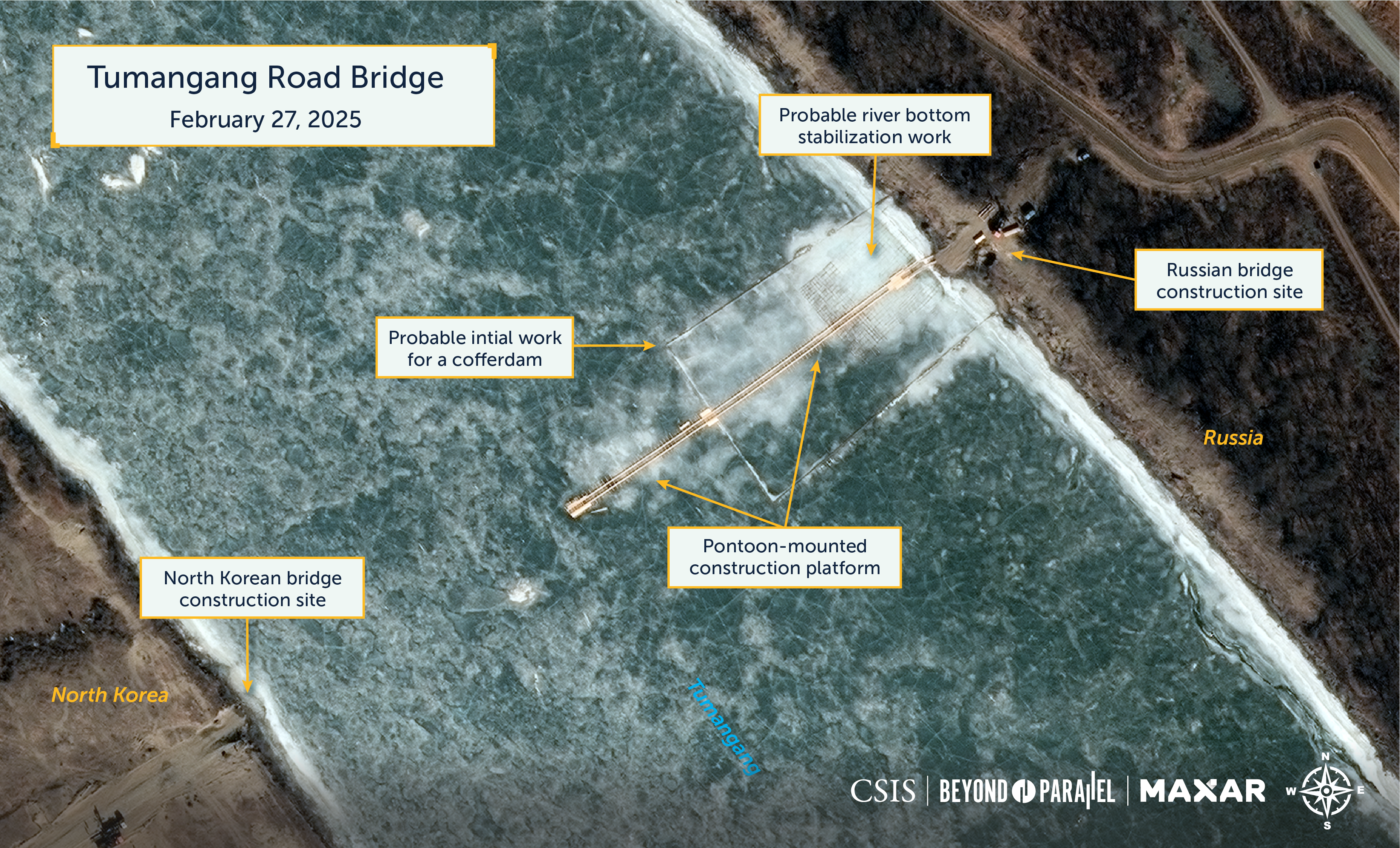
Additionally, a 70-meter-by-108-meter framework extends from the eastern shore. This may have been the initial stage of constructing a cofferdam or protecting early construction work from floating ice. A smaller 47-meter-by-36-meter framework is visible on the riverbed closer to the shore. This is likely to support work on stabilizing the shoreline to construct the approach abutment. Finally, approximately 795 meters downstream of the bridge construction site, a 75-meter-long length of the eastern shore has been cleared of trees and shrubs and partially graded.
At the North Korean bridge construction site along the western shore, the only notable activity is the grading of two support areas approximately 610 meters and 730 meters west-southwest of the bridge construction site and on the approach road down to the river. One of these support areas can reasonably be assumed to be for a future customs facility.
An image collected on March 14, 2025, shows that due to melting ice and snow further upriver, the river’s water level has risen, and the water flow has undoubtedly increased. This has impacted bridge construction significantly. The pontoon-mounted construction platform has been partially disassembled to prevent damage. Portions of the platform have been pulled onshore, and a large 38-meter-long section is now 230 meters downstream. Although anchored to the shore, this portion still projects into the current. Two additional small sections appear to have separated and are seen 360 meters further downstream along the eastern shore.

On the North Korean side, minor grading work is observed at the bridge construction site’s approach road and an area approximately 600 meters to the west.
An image collected a week later, on March 21, 2025, shows that the 38-meter-long section of the pontoon-mounted construction platform located 230 meters downstream no longer extends into the river. Instead, it has now been moored parallel to the shore. This change was likely undertaken due to increased water level and flow.
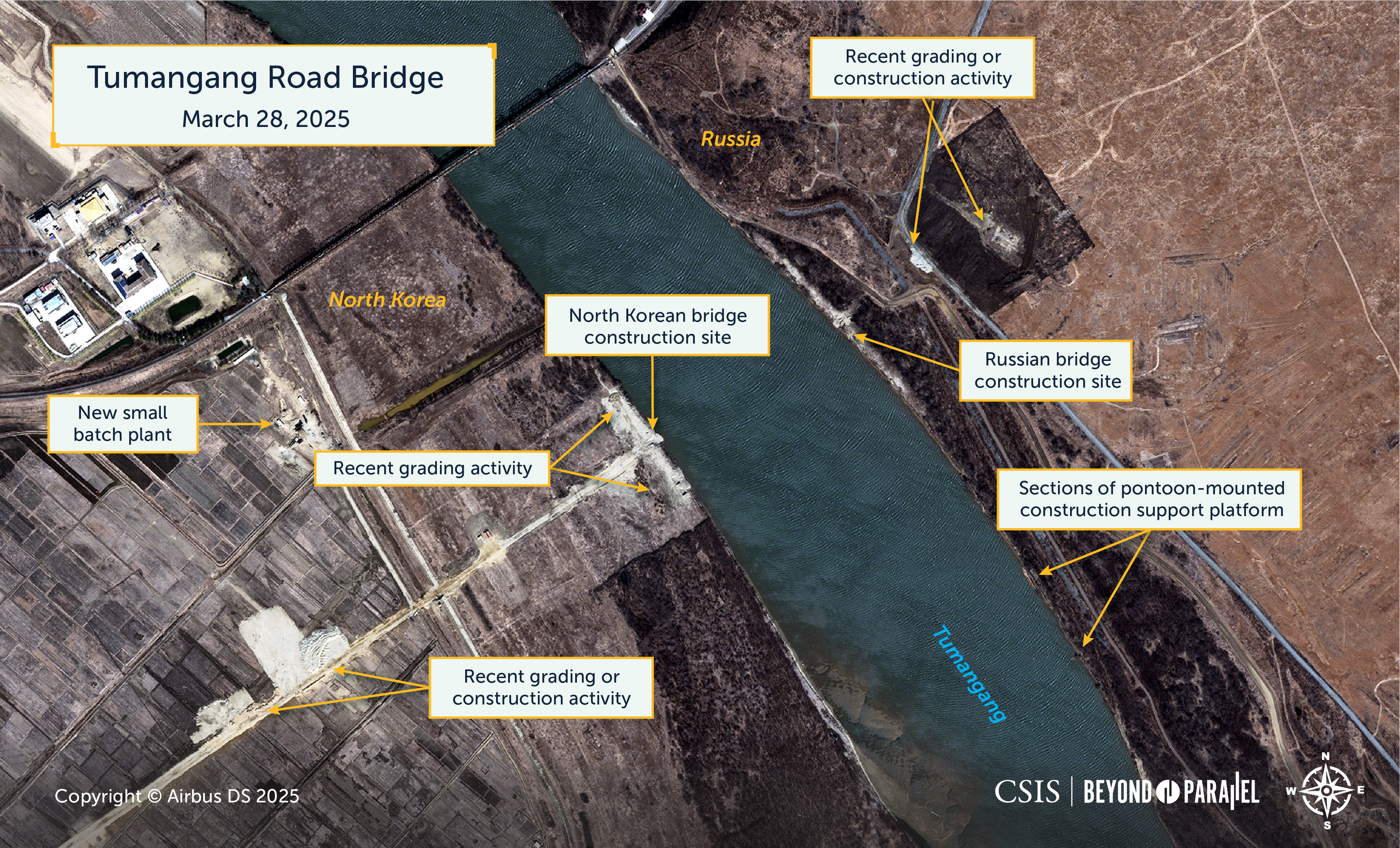
Finally, an image collected on March 28, 2025, provides a more current view of the status of bridge-related construction activity. Continued ice and snow melting upstream have maintained the river’s elevated level and flow. However, grading and construction activity, likely to support future bridge construction, is observed at 150 and 270 meters east of the bridge construction site on the Russian side of the river.
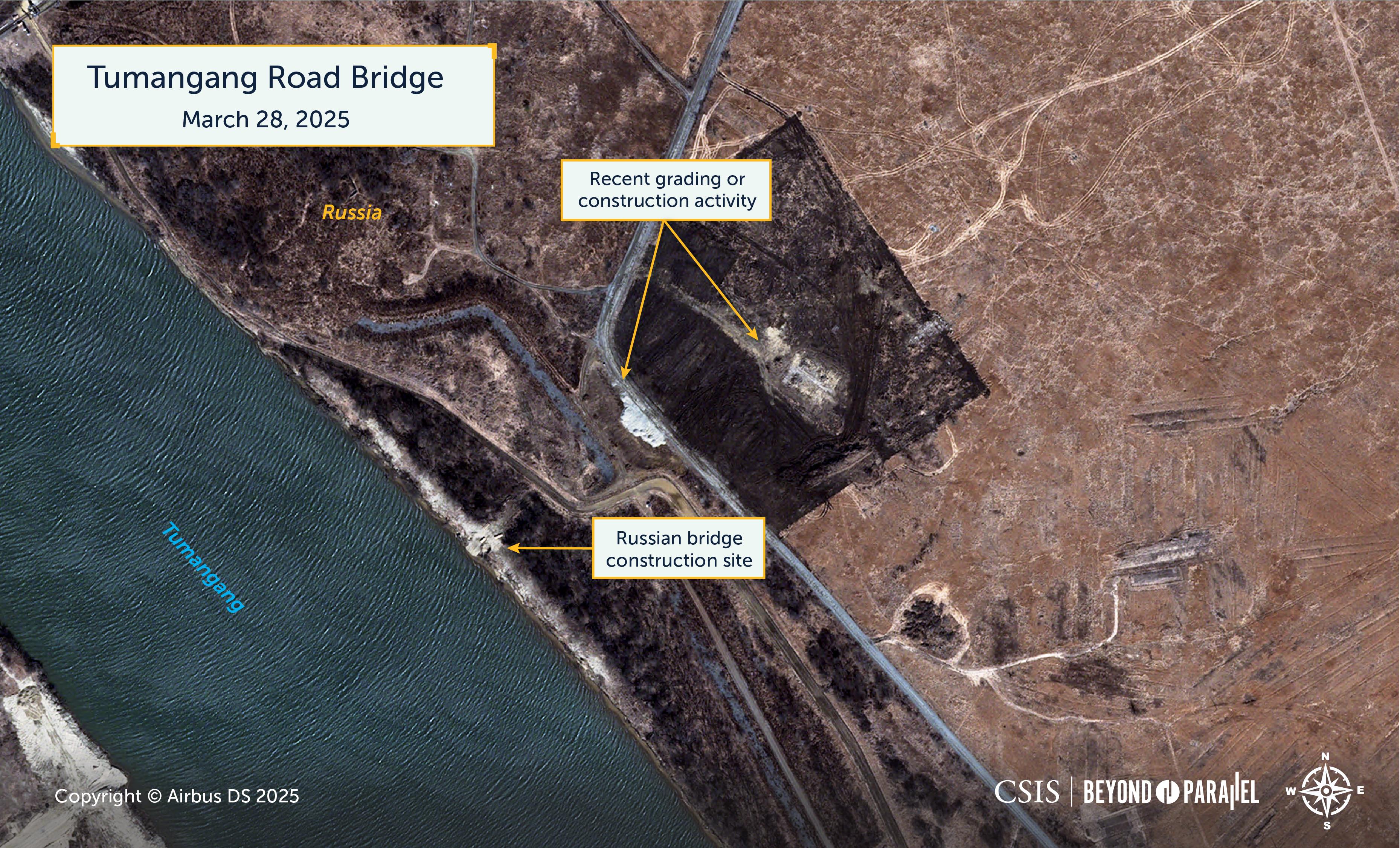
The location and positioning of the sections of the pontoon-mounted construction platform along the river’s eastern shore have not changed.

On the North Korean side of the river, ongoing grading and excavation work is observed along a 200-meter-long shoreline section, including the bridge construction site. Additional excavation work is observed at both support areas west-southwest of the bridging site. Finally, what appears to be a very small concrete batch plant has been established 500 meters west of the bridge construction site.

References
- Anton Sokolin, “Putin, Kim sign ‘comprehensive’ treaty outlining mutual defense obligations,” NK News, June 19, 2024, https://www.nknews.org/2024/06/kim-putin-summit-gets-underway-with-grand-ceremony-in-central-pyongyang/. ↩