Yongbyon Declassified Part II: Progress on Building IRT-2000 Reactor
North Korea’s pursuit of a nuclear weapons program is nearly six decades old. While archival documents have previously provided some evidence of North Korea’s intent to build weapons of mass destruction at an early stage in the Cold War, newly declassified satellite imagery from the Central Intelligence Agency gives us a more precise picture of how and exactly when North Korea started developing the fundamental components of its nuclear weapons program. This information is not only important for clarifying the historical record and for understanding North Korean intentions, but it gives present-day policymakers and nuclear scientists a way to assess and measure the specific components of the nuclear weapons program and the stages in which they were developed.
In the process of negotiations between the United States and North Korea in 2018, if and when the North Korean leadership decides to provide a complete verifiable list of all the components of their nuclear weapons program, an analysis of historical satellite imagery could prove critical in determining whether the list is accurate and reliable particularly with regard to the nuclear weapons facilities. Satellite imagery could provide supplemental information to nuclear weapons experts and facilitate on-the-ground inspections, if they are ultimately permitted by the North Korean regime.
Key Takeaways
-
- Early satellite imagery from the Central Intelligence Agency shows that in the course of a year, between July 15, 1964 and August 23, 1965, North Korea made significant progress in the construction of a new 4-megawatt thermal (MWt) IRT-2000 reactor at the Yongbyon Nuclear Research Center.
- This thermal reactor was obtained from the Soviet Union around mid-1964 and was the result of a treaty signed between North Korea and the Soviet Union in 1959 providing for technical assistance in helping to develop a DPRK nuclear research center.
- The construction of the thermal reactor was primarily a strategic decision driven by Cold War competition with South Korea and regional security concerns that arose when China developed an atomic reactor in 1956 with Soviet assistance.1
- North Korea also likely saw the development of a Chinese military nuclear program and the building of nuclear power plants in Eastern European countries such as Yugoslavia and Czechoslovakia as powerful symbols of national self-defense and self-reliance.2
- This may have driven the construction, between mid-1964 and mid-1965, of the foundation and exterior walls for the modified IRT-2000 reactor in North Korea.
- This imagery provides a more accurate picture of the various stages of the development of the Yongbyon nuclear complex, one of North Korea’s key assets in the nuclear program.
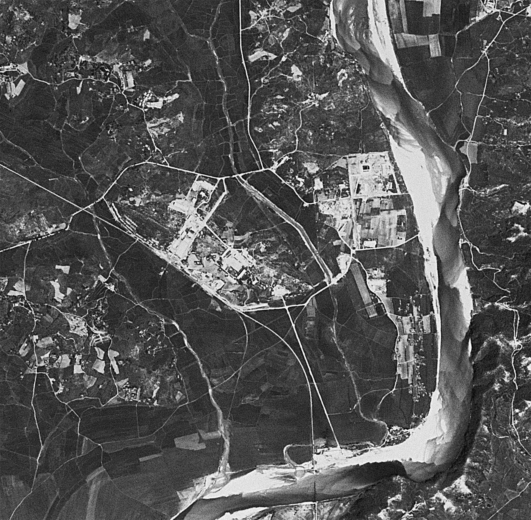
KH-4A Mission 1023 (August 23, 1965)
Acquired on August 23, 1965, slightly over a year after the image provided in Beyond Parallel’s report Yongbyon Declassified Part I (July 15, 1964), this 2.7-meter resolution image shows the general Yongbyon area remains primarily engaged in typical rural agricultural activity. At the nascent Yongbyon Nuclear Research Center steady but gradual progress has been made.
![]()
Image: An overview of the Yongbyon area showing the location of the initial stages of construction at the Yongbyon Nuclear Research Center, the city of Yongbyon and the villages in the immediate area (CIA, declassified KH-4 image, August 23, 1965).
At the Operations Area the road network has been improved and clearly defines the future extent of the area. The foundation and walls of the IRT-2000 research reactor appear to be almost complete, however, the roof of the building has not been finished.
![]()
Image: An overview of Operations Area of the Yŏngbyŏn Nuclear Research Center showing the IRT-2000 research reactor construction and administration and support area in relation to the villages of Yang-dong, Sang-dong, Pun’gang-ni and Chung-dong (CIA, declassified KH-4 image, August 23, 1965).
At least five support buildings are under construction or externally complete—most of these remain standing today. An electric sub-station to the west of the reactor is also under construction. On the southwest corner of the Operations area work continues on the administration and laboratory buildings and the foundations for at least two are just barely visible. Only agricultural activity is visible in the future support area to the south.
![]()
Image: An overview of the Operations Area showing the IRT-2000 research reactor, support buildings, administration building and laboratory building under construction (CIA, declassified KH-4 image, August 23, 1965).
![]()
Image: A close-up view of the Operations Area showing that a road network has clearly defined the area. The foundation and walls of the IRT-2000 research reactor are clearly visible, although the roof has not been finished. Also visible are at least five support buildings under construction or externally complete. An electric sub-station is under construction to the west of the reactor. An area to the southwest shows construction of administration and laboratory buildings has begun and the foundations for at least two are just visible (CIA, declassified KH-4 image, August 23, 1965).
Pun’gang-ni
The area south of the Operations Area around the village of Pun’gang-ni is the area that will become the future support area and site for the 5MWe and ELWR reactors. This area remains primarily engaged in typical rural agricultural activity.
![]()
Image: A view of the Pun’gang-ni area south of the Operations Area show it remains engaged in agricultural activity with no signs of work on the future support area or for the 5MWe and Experimental Light Water reactors (CIA, declassified KH-4 image, August 23, 1965).
Sang-dong
At Sang-dong the beginnings of a road network are starting to emerge and construction of housing units has progressed with several probably externally complete and foundations for others under construction.
![]()
Image: A close-up view of the village of Sang-dong showing that a road network is becoming defined and construction of housing units and support buildings has progressed with several probably externally complete and foundations for others under construction. The existing railroad station and railroad tracks are also clearly visible (CIA, declassified KH-4 image, August 23, 1965).
Yongch’u-ri and Surrounding Area
In the area east and south of the Kuryong-gang, around the village of Yongch’u-ri (i.e., Yongch’u-dong), only agricultural activity is observed. None of the future industrial infrastructure (e.g., sand and gravel plants, precast concrete plant, etc.) and civilian infrastructure (e.g., communications facility, etc.) in the area has yet been built.
![]()
Image: An overview of the area that will become the southern section of the Yŏngbyŏn Nuclear Research Center showing the future locations of major facilities around the village of Yongch’u-ri (CIA, declassified KH-4 image, August 23, 1965).
![]()
Image: A close-up view of the showing the future location for the 50MWe reactor north of Yongch’u-ri (CIA, declassified KH-4 image, August 23, 1965).
![]()
Image: A close-up view of the showing the future location for the Radio Chemistry Laboratory and “Building 500” (used for waste storage) northwest of Yongch’u-ri (CIA, declassified KH-4 image, August 23, 1965).
![]()
Image: A close-up view of the area southwest of the village of Yongch’u-ri showing the future location for the fuel fabrication, gas centrifuge and isotope production facilities (CIA, declassified KH-4 image, August 23, 1965).
References
- Balazs Szalontai and Sergey Radchenko, North Korea’s Efforts to Acquire Nuclear Technology and Nuclear Weapons: Evidence from Russian and Hungarian Archives, Working Paper No. 53, Washington, DC: Woodrow Wilson Center, 2006, p. 3-5, https://www.wilsoncenter.org/publication/north-koreas-efforts-to-acquire-nuclear-technology-and-nuclear-weapons-evidence-russian. ↩
- Ibid. ↩