North Korean Special Operations Forces: Hovercraft Bases (Part II)
Satellite imagery analysis shows that North Korea continues to develop its conventional military forces in a few targeted areas in addition to its high-profile nuclear weapons and ballistic missile programs. This is compatible with a broader North Korean strategy to develop stronger asymmetrical capabilities to offset the large imbalance of power between the DPRK and its neighbors.
Special operations forces are important to North Korea’s asymmetric warfare strategy and make up a large percent of the strength of the Korean People’s Army (KPA). Upon closer examination through satellite imagery, it has been observed that specialized hovercraft units within the Korean People’s Navy (KPN) could pose a greater threat to surrounding countries in the region as they are modernized and restructured. In particular, evidence of construction work at new hovercraft bases could suggest that North Korea will eventually move the units to a more forward deployed position closer to South Korean islands in the West Sea.
Key Takeaways
- Construction activity detected at two new North Korean hovercraft bases Sasŭlp’o (사슬포/고암포) and Yŏnbong-ni (련봉리) initially indicated that North Korea could be preparing to forward deploy existing hovercraft units from Kibong-dong and Tasa-ri to this area.
- However, thus far the Korean People’s Navy has not significantly increased the number of hovercraft deployed along the West Sea and has not forward deployed the hovercraft units from older bases.
- If North Korea does redeploy the existing hovercraft units at Kibong-dong and Tasa-ri to the Yŏnbong-ni hovercraft base it would represent the furthest forward deployment of any KPN hovercraft unit to date.
- This would also constitute a significant escalation of the navy sniper brigade threat to the ROK islands in the West Sea and ports along the coast; and potentially a political calculation that the ROK is too weak to counter such a move.
Sasulp’o
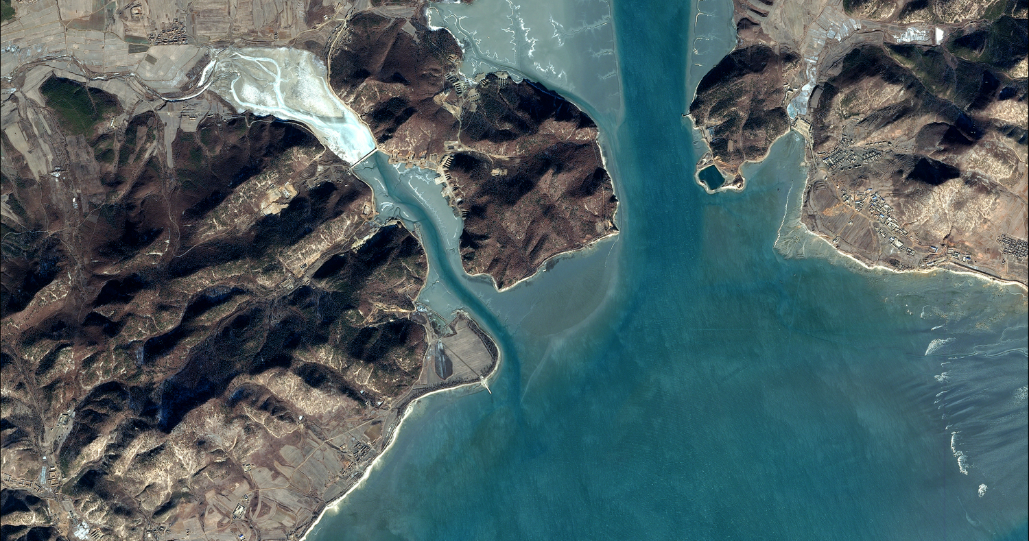
Located approximately 120 km southwest of Pyongyang within a shallow bay formed by the Namdae-ch’ŏn (Namdae stream) is the Sasŭlp’o hovercraft base.1 The base consists of two facilities—the main base (38.1920° 124.9045°) 1.5 km south of town of Sasŭlp’o and a smaller satellite base (38.2254° 124.9028°) across the Namdae-ch’ŏn, 400 meters southwest of the village of Yami-dong.2 While survey work undoubtedly was undertaken earlier, construction of the new hovercraft base is believed to have begun by early-2010 in a relatively flat area consisting of agricultural fields and a small stream that would be slightly redirected around the new facility. Construction was essentially complete by mid-2012.3
The main facility occupies an irregularly shaped area measuring approximately 1,000-meters-by-900-meters, encompasses approximately .38 km2 (94 acres) and consists of four headquarters, administration, housing and support compounds, three hovercraft storage compounds, and a small pre-existing agricultural reservoir that appears to also be intended to be used as a testing pond. All the compounds are connected to a central access road that also serves as a taxiway for hovercraft leading down to the Namdae-ch’ŏn. There is, however, no concrete launching ramp.

The three hovercraft compounds are different in configuration and construction from those previously constructed elsewhere in the country. Each is surrounded by a high earthen revetment with a narrow entrance leading to the central taxiway and consists of a small support building and a number of reinforced concrete hovercraft shelters arranged in a “C” configuration around a central yard. These shelters, measure approximately 10-meters-by-24-meters, are constructed of reinforced concrete walls and arched roofs, are open to the front and rear and are large enough to accommodate the KONG BANG II/III or other classes of hovercraft in KPN service. While they do provide somewhat better protection from blast and fragmentation damage than the existing sheds at Kibong-dong and Tasa-ri, they do not provide for protection from direct attack.
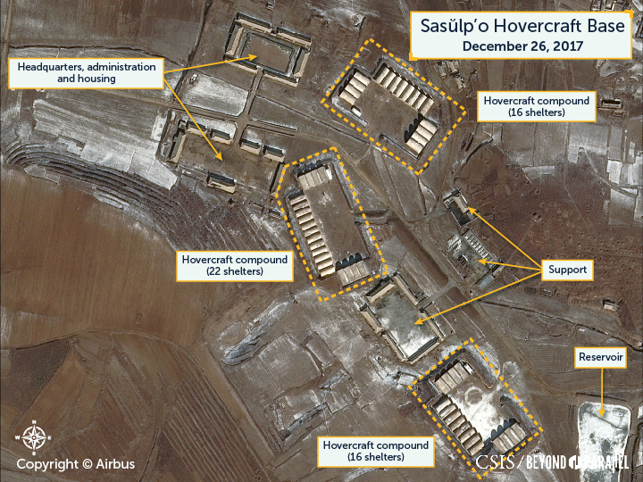
Two of the compounds consist of 16 shelters each and measure approximately 154-meters-by-95-meters and 164-meters-by-95-meters, respectively. The third facility consists of 20 shelters and measures approximately 180-meters-by-85-meters. These three hovercraft compounds can shelter a total of 52 hovercraft.

Yami-dong
The smaller satellite base southwest of Yami-dong occupies an irregularly shaped area measuring approximately 500-meters-by-210-meters, encompasses approximately .10 km2 (25 acres) in a shallow cove and consists of a combined headquarters, administration, housing and support compound, and a single hovercraft compound with an approximately 50-meter-by-35-meter concrete launching ramp. There is also an approximately 25-meter-by-9-meter pier connected to the base on its western corner.
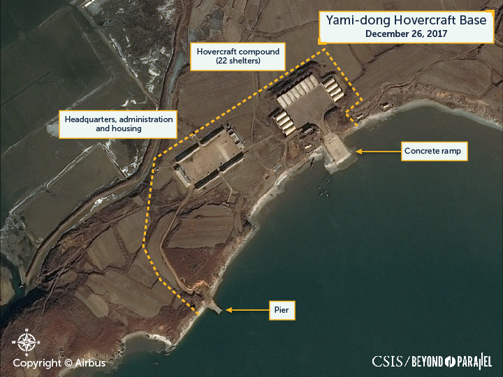
The hovercraft compound is similar to those at the main base being surrounded by a high earthen revetment with a narrow entrance leading directly to the concrete launching ramp, consists of 16 reinforced concrete hovercraft shelters arranged in a “C” configuration around a central yard, has a small support building, and measures approximately 150-meters-by-90-meters.
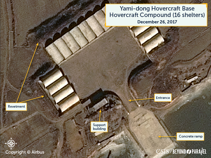
Taken together, the four hovercraft compounds at the main Sasŭlp’o and the satellite Yami-dong bases can shelter a total of 68 hovercraft. This figure of 68 represents two less the total number of hovercraft available at the Kibong-dong and Tasa-ri hovercraft bases (68 vs. 70).4
The construction of the Sasŭlp’o and Yami-dong bases was initially assessed from two perspectives. First, was that it was an indication that North Korea was preparing for a dramatic expansion and forward deployment of new hovercraft units. Second, that North Korea was preparing for the forward deployment of the existing hovercraft units at Kibong-dong and Tasa-ri. Either of which would represent the furthest forward deployment of any KPN hovercraft unit to date and an escalation of the navy sniper brigade threat to the ROK islands in the West Sea and ports along the coast.
For example, the distances to the northernmost ROK island of Baegnyeong-do (백령도) and the port city Incheon (인천) is reduced from approximately 182 km and 373 km when operating from the Kibong-dong hovercraft base to approximately 50 km and 215 km, respectively, from the Sasŭlp’o and Yami-dong bases. Thus, reducing the voyage time to approximately 30 minutes and 2.5 hours, respectively. Significantly, about half of a voyage from Sasŭlp’o and Yami-dong to Baegnyeong-do would be masked from South Korean radars located on Baegnyeong-do by the Yongyŏn-bando (i.e., Yongyŏn Peninsula) affording a KPN assault on the island a higher degree of surprise.
The KPN, however, neither significantly increased the number of its hovercraft deployed along the West Sea, nor forward deployed the hovercraft units from Kibong-dong or Tasa-ri. Subsequently, the assessment of the Sasŭlp’o and Yami-dong bases evolved to the understanding that it was to shelter existing hovercraft units that were forward deployed from rear bases during an emergency. Then during 2014-2015 this assessment began to change with the commencement of construction on a new hovercraft near Yŏnbong-ni, 40 km to the southeast, on the base of the Yongyŏn-bando (i.e., Yongyŏn Peninsula) and immediately north of the Northern Limit Line.
Most recently, during the summer of 2017, North Korea began a land reclamation project in the upper Namdae-ch’ŏn that appears to indicate that the main Sasŭlp’o hovercraft base will be abandoned—although likely repurposed—in favor of the new base at Yŏnbong-ni.
As of December 26, 2017, this reclamation project has constructed a subsurface rock dam to slow the flow of water in-and-out of the upper Namdae-ch’ŏn and two levees upstream of the dam. Both of these levees are unfinished but have provisions for flood gates to control water levels. One of the levees, however, now blocks access to the main Sasŭlp’o hovercraft base.
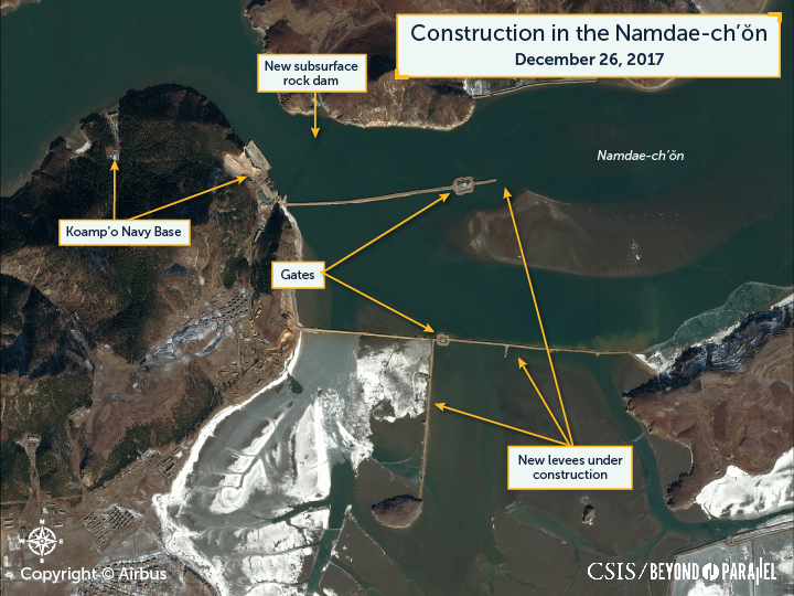
While hovercraft can cross low objects, they can’t cross high levees unless special ramps are constructed for the hovercraft to climb over—none of which are evident in satellite as of December 2017. Since no such provisions are evident it would appear to confirm that the main Sasŭlp’o base will be abandoned for hovercraft usage.5
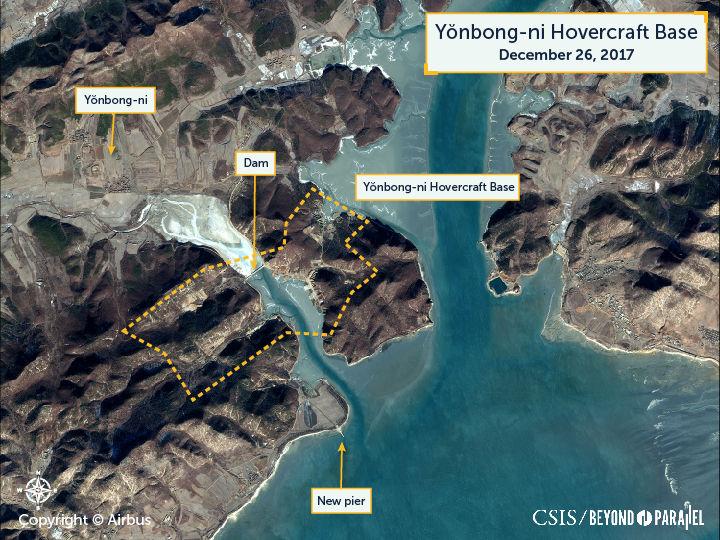
Yonbong-ni
Located approximately 135 km southwest of Pyongyang within a small inlet is the construction site for the Yŏnbong-ni hovercraft base. The base consists of two groupings of facilities and hovercraft shelters separated by a newly constructed dam (37.907892° 125.221185°) 1.5 km southeast of the village of Yŏnbong-ni. When completed the Yŏnbong-ni hovercraft base will occupy an irregularly shaped area measuring approximately 1,600-meters-by-700-meters—not including a recently constructed pier 1.4 km to the south. In total, the base encompasses approximately .68 km2 (168 acres) and consists of headquarters, administration, housing and support compounds, and a large number of hovercraft shelters—nineteen 2- and 3-bay hovercraft shelters as of December 2017.
Yonbong-ni (East)
During early 2014 North Korea began construction of dam approximately 1.5 km southeast of the small village of Yŏnbong-ni and across a small inlet formed by a small peninsula on the east and the mainland on the west. Concurrently, a small village was constructed, probably to house construction workers, at the head of the inlet and 800 meters east of Yŏnbong-ni. Several months later, and before the dam was completed, a road was constructed south along the shore on the east of the dam. Two excavations were subsequently observed 100-200 meters south along this road. These excavations were unusual in that they were small, cut into the steep sides of a peninsula, and the excavated material, rather than being used for the dam or transported elsewhere, was being push into the sea to extend the shoreline out in a series of small mounds.
By late-2015 satellite imagery showed that the road on the east side of the dam had been extended further south and there were now a total of five small excavations, with the newest one being 500 meters south of the dam. It was at this point that the first solid evidence was observed that indicated a new hovercraft base was under construction. This was the erection of two 10-to-12-meter-wide arched walls at the rear of several of the excavations indicating that these were intended to accommodate 2-bay concrete-reinforced hovercraft shelters. The material that was observed being pushed into the sea would form the foundations for future launching ramps.
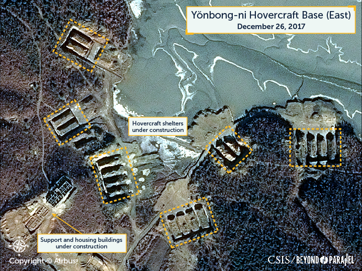
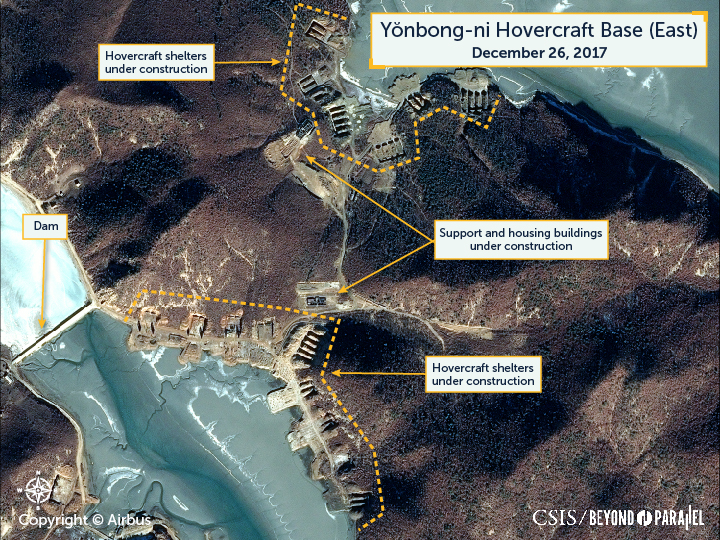
During 2016, on the east side of the dam there were excavations for eight 2-bay and one 4-bay hovercraft shelters, a dirt road was built across to the east side of the peninsula, and it was observed that several housing or support buildings were under construction. On the east shore of the peninsula a single 2-bay shelter was under construction.
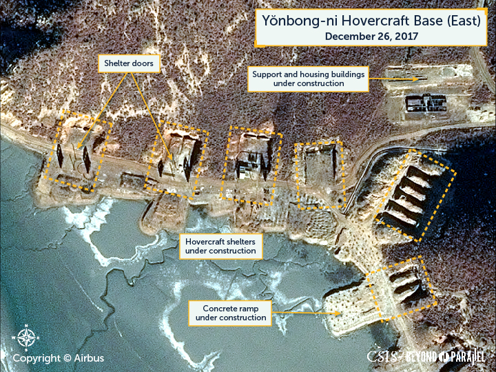
In satellite imagery from December 26, 2017, it shows that on the east of the dam considerable construction progress has been achieved across the peninsula. There were now a total of eleven 2-bay and 4 four-bay shelters in various stages of construction—a majority of which had their rear arched walls in place, several shelters have what appear to be entrance doors in place, and two small support areas were under construction.
Yonbong-ni (West)
By late-2015, it was observed that two areas west of the dam were also being cleared. The first was 350 meters west of the dam and measured approximately 70-meters-by-90-meters and the second was 180 meters to the northwest of the dam and measured approximately 65-meters-by-30-meters. Finally, a road had been extended from the west side of the dam south, 300 meters along the shore, to a shallow valley.
During 2016 significant progress was achieved on the construction of this part of the base. Satellite imagery showed that on the west side of the dam, the large clearing had been expanded to approximately 215-meters-by-135-meters and although no buildings were yet erected it is likely intended for headquarters, administration, housing and support buildings, a new housing area was erected 150 meters west of the dam with approximately 10 small buildings, in the shallow valley to the south of the dam four 4-bay hovercraft shelters were being excavated and a housing and support area erected 500 meters to the west.
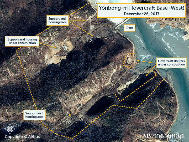
Most recently, satellite imagery on December 26, 2017, shows that slow but steady progress had been made on the west side of the dam.
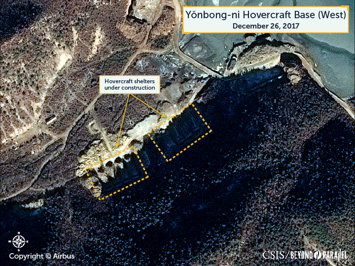
Most notably, is that all four of the 4-bay hovercraft shelter excavations now had their rear arched walls in place and a new 80-meter-by-7-meter pier has been constructed on a point 1.4 km south of the dam that will likely be associated with the base.

In sum, the Yŏnbong-ni hovercraft base possesses a number of characteristics that enhances its survivability over all existing hovercraft bases,
- The base facilities are dispersed and separated by low hills
- The hovercraft shelters are excavated from hillsides and possess rear walls and potentially reinforced doors across their entrances
- Given that they were excavated out of the side of hills a majority of the new shelters could be covered by earth to provide additional protection
- A number of the 2-bay shelters have direct access to the water allowing for rapid deployment under emergency conditions
While none of these features provide protection from direct attack they do provide significantly better protection from blast and fragmentation damage than any of the existing sheds or shelters found at other hovercraft bases.
As of December 2017, the hovercraft shelters at the Yŏnbong-ni hovercraft base can shelter a total of 54 hovercraft—two more than the main Sasŭlp’o hovercraft base (54 vs. 52)—and are large enough to accommodate the KONG BANG II/III or other classes of hovercraft in KPN service. If construction continues at its present pace it is likely that the reinforced concrete roofs for the shelters will be poured starting in 2018 and that a majority of the headquarters, administration, housing and support compounds will be completed during 2019.
While the location of the Yŏnbong-ni hovercraft base offers no significant timewise advantages for an assault on Baegnyeong-do (the island can still be reached in 30 minutes), it does offer the advantage of being able to more easily land an assault force from the south and east without having to pass the heavily defended north side of the island. More significantly, hovercraft from the Yŏnbong-ni base can quickly reach the ROK islands of Daecheong-do (Taech’ŏng-do), Socheong-do (Soch’ŏng-do) and Yeonpyeong-do (Yŏnp’yŏng-do) in approximately 30, 40 and 70 minutes, respectively; and the port city of Incheon can be reached in 90 minutes.6
If North Korea does redeploy the existing hovercraft units at Kibong-dong and Tasa-ri to the Yŏnbong-ni hovercraft base it would represent: the furthest forward deployment of any KPN hovercraft unit to date; a significant escalation of the navy sniper brigade threat to the ROK islands in the West Sea and ports along the coast; and potentially a political calculation that the ROK is too weak to counter such a move.
References
- Because part of the hovercraft base is located in the general area of the older Koamp’o (고암포) Navy Base it sometimes identified using this name in media reports. ↩
- Bermudez Jr., Joseph S. “New Hovercraft Base at Sasŭlp’o,” KPA Journal, Vol. 2, No. 2, February 2011, pp. 1-9, http://www.kpajournal.com/vol-2-no-2-february-2011/; “Sighting of DPRK Military Hovercraft in Satellite Photos,” YTN, August 3, 2010; “DPRK Trains Special Forces to Seize 5 ROK Border Islands,” JoongAng Ilbo, December 31, 2010; and “Satellite Images Reveal Hovercraft Base in North Korea,” Jane’s Defence Weekly, February 25, 2011, jdw.janes.com; See also, Bermudez, Joseph S., Jr. North Korean Hovercraft Forces: Part 3 Sasulp’o. Longmont, CO: DigitalGlobe, June 8, 2011; and Bermudez, Joseph S., Jr. North Korean Special Forces – Second Edition, Annapolis: U.S. Naval Institute Press, November 1997, pp. 194-209. ↩
- “North Korea Naval Base Nearly Complete,” UPI, May 29, 2011, http://www.upi.com/Top_News/World-News/2011/05/29/North-Korea-naval-base-nearly-complete/UPI-84331306642680/; Adewunmi, Bim. “North Korea’s new weapon: the hovercraft,” Guardian, May 30, 2011, http://www.guardian.co.uk/world/2011/may/30/north-korea-attack-hovercraft; “NK Nears Completion of Naval Base Construction,” KBS World, May 30, 2011, http://world.kbs.co.kr/english/news/news_Po_detail.htm?No=81854; and Bermudez Jr., Joseph S. “New Hovercraft Base at Sasŭlp’o,” KPA Journal, Vol. 2, No. 2, February 2011, pp. 1-9, http://www.kpajournal.com/vol-2-no-2-february-2011/. ↩
- Bermudez Jr., Joseph S. “New Hovercraft Base at Sasŭlp’o,” KPA Journal, Vol. 2, No. 2, February 2011, pp. 1-9, http://www.kpajournal.com/vol-2-no-2-february-2011/. ↩
- The abandoning of the Sasŭlp’o base, and the valuable resources that went into its construction, is likely an indicator of the importance being given by the Kim Jong-un regime to increasing agricultural output nationwide (e.g., the Tideland Reclamation Complex in P’yŏngbuk, etc.). ↩
- These estimates are the worst case and are unlikely to be achieved under wartime conditions. ↩