Yongbyon Declassified Part III: Significant Construction of Facilities at Nascent Yongbyon Nuclear Site by 1966
KH-4A Mission 1029, February 11, 1966
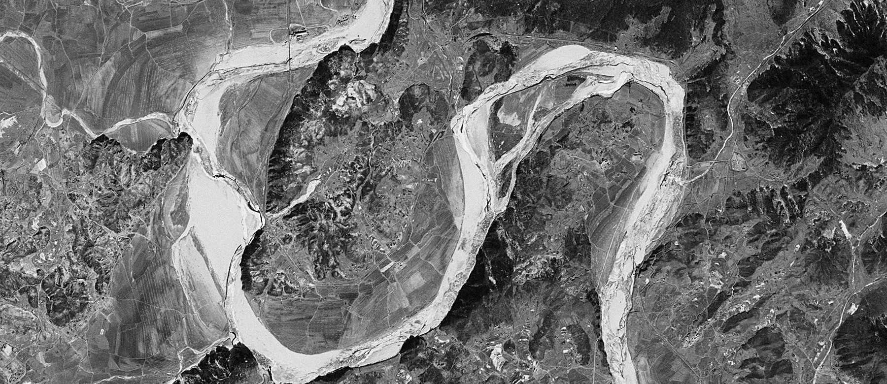
Acquired seven months after the image provided in Yongbyon Declassified Part II (August 23, 1965) this 2.7-meter resolution image covers the Yongbyon area on February 11, 1966. While the general area remains primarily engaged in agricultural activity typical of rural North Korea during the 1960s, significant construction activity is observed at the nascent Yongbyon Nuclear Research Center and adjacent village of Sang-dong.
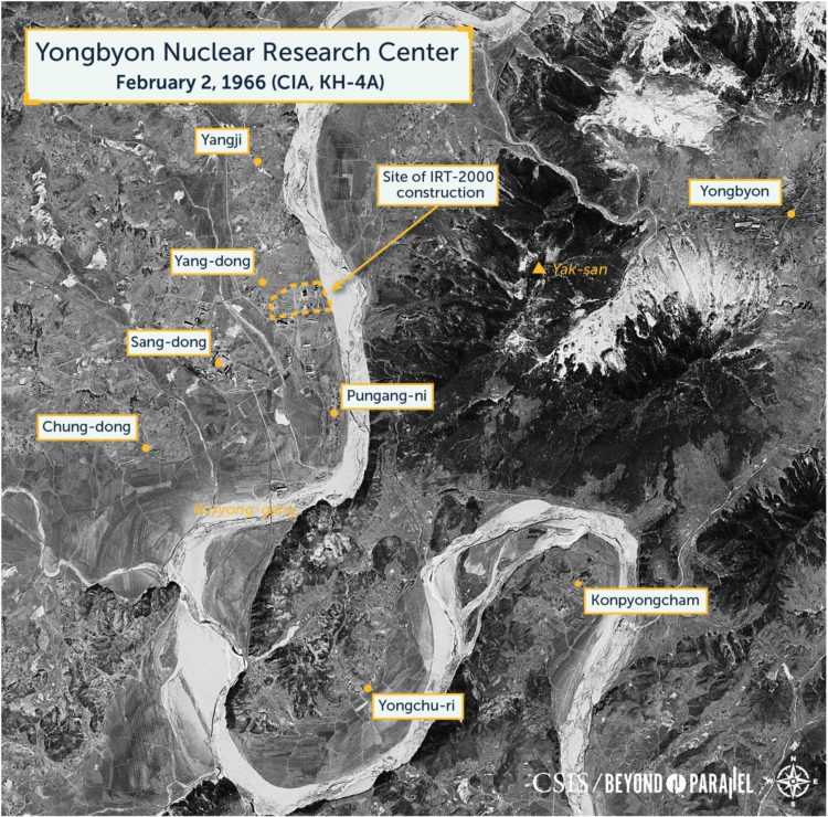
An overview of the Yongbyon area showing the location of the Yongbyon Nuclear Research Center, city of Yongbyon and the villages in the immediate area. (CIA, declassified KH-4A image, February 11, 1966)
At the Operations Area, what appears to be a fence has been erected around most of the perimeter. The IRT-2000 reactor building is externally complete and the shadow of the support crane on top of the building is just visible on the north side of the structure. Five primary support buildings appear to be externally complete, including an incinerator building and exhaust tower whose shadow can be seen immediately to the north of the structure.1 The electric sub-station to the west of the reactor may also be complete.
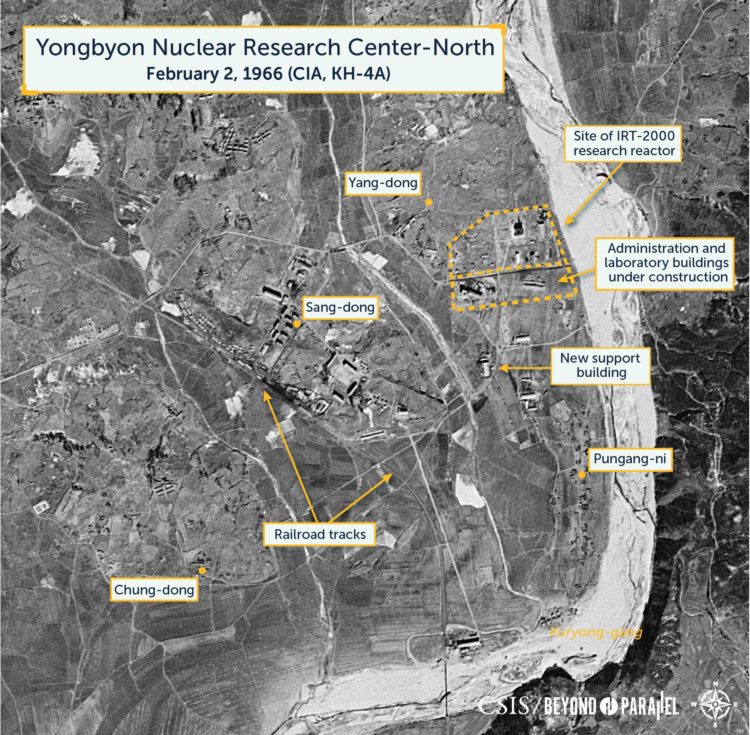
An overview of northern section of the Yongbyon Nuclear Research Center showing the Operations Area (with IRT-2000 research reactor), and construction activity of the laboratory/administration buildings and the first building in the support area. Also visible are the villages of Yang-dong, Sang-dong, Pungang-ni and Chung-dong. (CIA, declassified KH-4A image, February 11, 1966)
South of the Operations area work has continued on the first laboratory/administration building and it appears to be partially complete. Immediately to the east of this, excavation has begun for the foundation of a second laboratory/administration building.
Approximately 300 meters south of the first laboratory/administration building the first of numerous support buildings has be erected. As judged by high-resolution imagery during the 2000s this particular building appears to be a fabrication shop. This general area will house a thermal plant, laboratories and numerous additional support buildings in the future.
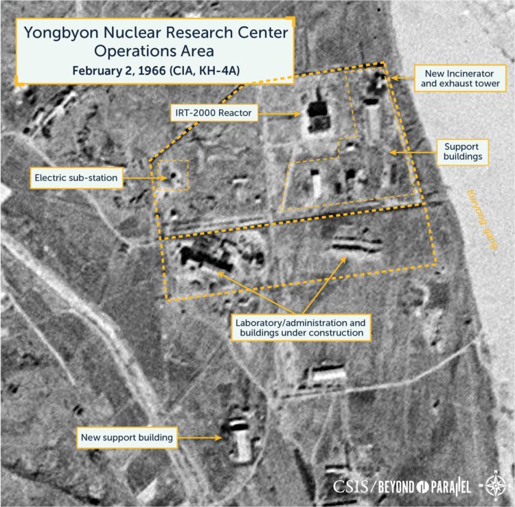
A close-up view of the Operations Area showing that what appears to be a fence has enclosed much of the area. The IRT-2000 rector building is externally complete and the shadow of the support crane on top of the building is just visible on the north side of the structure. Five primary support buildings appear to be externally complete, including an incinerator building and exhaust tower whose shadow can be seen immediately to the north of the structure. To the south the first laboratory/administration building appears to be partially complete and excavation for the foundation of a second is visible immediately to the east. Further south a new support building (a fabrication shop) has been erected. (CIA, declassified KH-4A image, February 11, 1966)
Pungang-ni
The area around the village of Pungang-ni (site for the future 5MWe and ELWR reactors and what would become known locally as the “Pungang District”) remains primarily engaged in typical rural agricultural activity. Southwest of Pungang-ni, on the shore of the Kuryong-gang, the concrete plant first observed in the August 23, 1965 image appears to be nearing completion. When complete it would produce, among other products, preformed concrete components that will be used in construction projects in Sang-dong, the Yongbyon Nuclear Research Center and the general area. Sand and gravel for the plant will be supplied by future dredging operations in the Kuryong-gang.
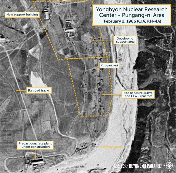
The Pungang-ni area remains engaged primarily in agricultural activity although a new support building (a fabrication shop) for the Operations Area has been erected to the west. To the southwest of Pungang-ni the concrete plant first observed in the August 23, 1965 image appears to be nearing completion. (CIA, declassified KH-4A image, February 11, 1966
Sang-dong
In the town of Sang-dong numerous housing, government and cultural buildings have been completed and others are under construction as indicated by new foundations and excavations. At least some of these are probably occupied. Some work appears to have been undertaken at the railroad station/yard, however, if this is correct the resolution is insufficient to determine the exact nature of this activity.
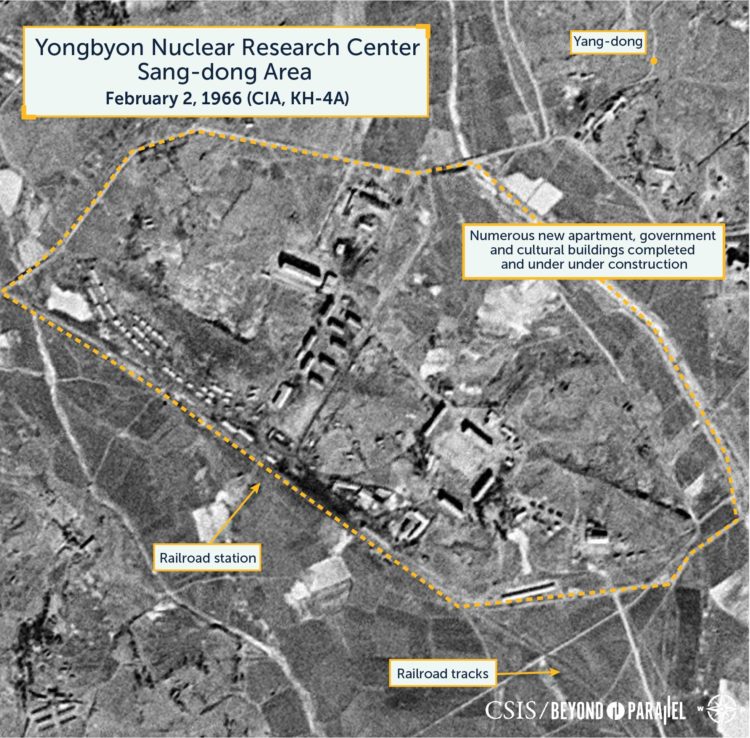
A close-up view of the village of Sang-dong showing that numerous housing, government and cultural buildings have been completed and others are under construction. Some work appears to have also been undertaken at the railroad station/yard. (CIA, declassified KH-4A image, February 11, 1966)
Yongchu-ri and Surrounding Area
In the area to the southeast and across the Kuryong-gang—the area that will house the future Radiochemistry Laboratory, 50MWe reactor, fuel fabrication and other facilities—only agricultural activity is observed.
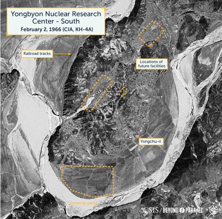
An overview of the area that will become the southern section of the Yongbyon Nuclear Research Center showing the future locations of major facilities around the village of Yongchu-ri. (CIA, declassified KH-4A image, February 11, 1966)
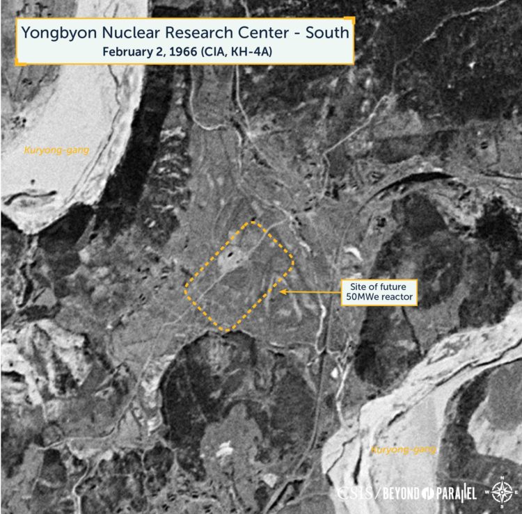
A close-up view of the showing the future location for the 50MWe reactor north of Yongchu-ri. (CIA, declassified KH-4A image, February 11, 1966)
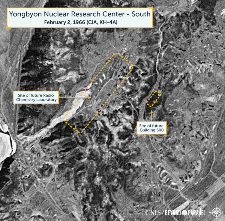
A close-up view of the showing the future location for the Radio Chemistry Laboratory and “Building 500” (used for waste storage) northwest of Yongchu-ri. (CIA, declassified KH-4A image, February 11, 1966)
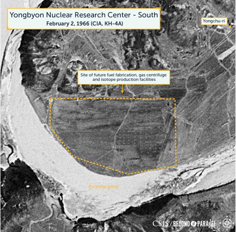
A close-up view of the area southwest of the village of Yongchu-ri showing the future location for the fuel fabrication, gas centrifuge and isotope production facilities. (CIA, declassified KH-4A image, February 11, 1966)
References
-
This tower is sometimes described as a burn or flame tower. ↩